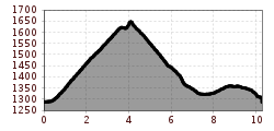
Großer MutzkopfOpening hours:closedDifficulty:easyLength:10.3 kmDuration:4:00 hElevation uphill:507 mSee trailSee trail: Großer Mutzkopf
©-TVB-Tiroler-Oberland-Kaunertal-Die-West-Barrierefrei-Langlaufen-1 (15).jpg © Die West GmbH Kaser circuit: adaptive cross-country skiing trail in the Kaunertal ValleyOpening hours:closedDifficulty:easyLength:1.0 kmElevation uphill:10 m:Style: Skating, ClassicGo to Cross-country skiing trailGo to Cross-country skiing trail: Kaser circuit: adaptive cross-country skiing trail in the Kaunertal Valley
©-TVB-Tiroler-Oberland-Nauders-Rudi-Wyhlidal-Langlaufen-Mutzkopf-2018 (14).jpg © Rudi Wyhlidal MoasloipeOpening hours:closedDifficulty:mediumLength:8.0 kmElevation uphill:140 m:Style: Skating, ClassicGo to Cross-country skiing trailGo to Cross-country skiing trail: Moasloipe
Reschenloipe Nauders - StandardloipeOpening hours:closedDifficulty:mediumLength:6.5 kmElevation uphill:25 m:Style: Skating, ClassicGo to Cross-country skiing trailGo to Cross-country skiing trail: Reschenloipe Nauders - Standardloipe
Nauders mountain trailDifficulty:mediumLength:18.0 kmDuration:7:00 hElevation uphill:407 mSee trailSee trail: Nauders mountain trail
©-TVB-Tiroler-Oberland-Nauders-Rudi-Wyhlidal-Langlaufen-Mutzkopf-2018 (14).jpg © Rudi Wyhlidal Langlaufroute Schwarzer SeeOpening hours:closedDifficulty:difficultLength:10.0 kmElevation uphill:200 m:Style: Skating, ClassicGo to Cross-country skiing trailGo to Cross-country skiing trail: Langlaufroute Schwarzer See
Oberer Gerry TrailOpening hours:openDifficulty:mediumLength:1.2 kmGo to biketourGo to biketour: Oberer Gerry Trail
Schwarzer and Grüner SeeDifficulty:easyLength:8.3 kmDuration:4:30 hElevation uphill:368 mSee trailSee trail: Schwarzer and Grüner See
Nauders, Plamort Trail_Tirol Werbung_Schels Sebastian_Nauders (1) © Tirol Werbung | Sebastian Schels Plamort TrailOpening hours:openDifficulty:Very easyLength:2.5 kmGo to biketourGo to biketour: Plamort Trail
Winter walk Schwarzer See, NaudersDifficulty:easyLength:10.5 kmDuration:3:30 hElevation uphill:255 mGo to winter hikeGo to winter hike: Winter walk Schwarzer See, Nauders
Evening winter hike Kleinmutzkopf, NaudersDifficulty:easyLength:6.0 kmDuration:2:00 hElevation uphill:70 mGo to winter hikeGo to winter hike: Evening winter hike Kleinmutzkopf, Nauders
BergkasteltrailOpening hours:openDifficulty:mediumLength:5.5 kmGo to biketourGo to biketour: Bergkasteltrail
Brandenburgerhaus © Katharina Schatz Ötztal Trek Stage 15Difficulty:difficultLength:6.5 kmDuration:2:30 hElevation uphill:332 mSee trailSee trail: Ötztal Trek Stage 15
©-TVB-Tiroler-Oberland-Kaunertal-Michael-Veit-Klima-Führer-2018-Gepatsch-Nasserein © Michael Veit Sternenweg im GepatschDifficulty:mediumLength:3,620.0 kmDuration:1:30 hElevation uphill:202 mSee trailSee trail: Sternenweg im Gepatsch
©-TVB-Tiroler-Oberland-Kaunertal-Daniel-Zangerl-Aifneralm-2016-(19).jpg © Daniel Zangerl Rolli-Wanderung Aifner AlmDifficulty:mediumLength:6.0 kmDuration:2:30 hElevation uphill:460 mSee trailSee trail: Rolli-Wanderung Aifner Alm
©-TVB-Tiroler-Oberland-Kaunertal-Daniel-Zangerl-2016-Nassereinalm-(5).jpg © Daniel Zangerl Rolli-Wanderung NassereinalmDifficulty:mediumLength:5.5 kmDuration:1:45 hElevation uphill:269 mSee trailSee trail: Rolli-Wanderung Nassereinalm
©-TVB-Tiroler-Oberland-Kaunertal-Die-West-Barrierefrei-Langlaufen-1 (3).jpg © Die West GmbH Adaptive cross country skiing circuit Anger at Kaunertal ValleyOpening hours:closedDifficulty:easyLength:1.0 kmElevation uphill:5 m:Style: Skating, ClassicGo to Cross-country skiing trailGo to Cross-country skiing trail: Adaptive cross country skiing circuit Anger at Kaunertal Valley
©-TVB-Tiroler-Oberland-Kaunertal-Daniel-Zangerl-2016-Gepatschhaus-(3).jpg © Daniel Zangerl Rolli-Wanderung GepatschhausLength:8.5 kmDuration:1:45 hElevation uphill:156 mSee trailSee trail: Rolli-Wanderung Gepatschhaus
©-TVB-Tiroler-Oberland-Kaunertal-Daniel-Zangerl-Falkaunsalm-2016-(6).jpg © Daniel Zangerl Rolli-Wanderung FalkaunsalmDifficulty:mediumLength:4.5 kmDuration:1:45 hElevation uphill:392 mSee trailSee trail: Rolli-Wanderung Falkaunsalm
©-TVB-Tiroler-Oberland-Kaunertal-Die-West-Barrierefrei-Langlaufen-1 (19).jpg © Die West GmbH Adaptive cross-country skiing: Loch circuit in the Kaunertal ValleyOpening hours:closedDifficulty:easyLength:1.0 kmElevation uphill:10 m:Style: Skating, ClassicGo to Cross-country skiing trailGo to Cross-country skiing trail: Adaptive cross-country skiing: Loch circuit in the Kaunertal Valley
©-TVB-Tiroler-Oberland-Kaunertal-Michaela-Gasser-Mark-Handbikebattle-2017-8863.jpg © Michaela Gasser-Mark Handbike Route Kaunertaler GletscherDifficulty:difficultLength:27.5 kmDuration:4:00 hElevation uphill:1,500 mGo to biketourGo to biketour: Handbike Route Kaunertaler Gletscher
©-TVB-Tiroler-Oberland-Kaunertal-Michael-Veit-Klima-Führer-2018-Talwanderweg-Vergötschen-Platz-2018 © Michael Veit Talwanderweg KaunertalDifficulty:easyDuration:2:30 hElevation uphill:295 mSee trailSee trail: Talwanderweg Kaunertal
Gallruth Stollenwanderung_Daniel Zangerl.jpg © Daniel Zangerl Kaunerberger WasserwegOpening hours:closedDifficulty:mediumLength:15.2 kmDuration:6:00 hElevation uphill:935 mSee trailSee trail: Kaunerberger Wasserweg
©-TVB-Tiroler-Oberland-Kaunertal-Susanne-Larcher-Fernergries-Roter-Felsen.jpg © Susanne Larcher Gletscherlehrpfad GepatschfernerDifficulty:mediumLength:8.4 kmDuration:3:45 hElevation uphill:400 mSee trailSee trail: Gletscherlehrpfad Gepatschferner
Panoramaweg Aifner Alm - Falkauns AlmOpening hours:openDifficulty:mediumLength:6.2 kmDuration:2:40 hElevation uphill:300 mSee trailSee trail: Panoramaweg Aifner Alm - Falkauns Alm
Give feedback for a chance to win a special holiday experience!Click here for the surveyClick here for the survey