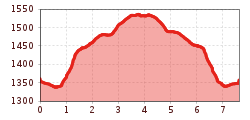
Open interactive mapOpen this POI on the interactive mapElevation profiledownloadMoaßstrecke - Mösle - Pflanzgarten.gpx
Kaiserjochhaus © Lechtal Tourismus Lechtaler Höhenweg: 3. Etappe Kasierjochhaus-Ansbacher HütteDifficulty:difficultLength:7.9 kmDuration:4:15 hElevation uphill:511 mSee trailSee trail: Lechtaler Höhenweg: 3. Etappe Kasierjochhaus-Ansbacher Hütte
Kaiserjochhaus © Lechtal Tourismus Lechtaler Höhenweg: 3. Etappe Kasierjochhaus-Ansbacher HütteDifficulty:difficultLength:11.3 kmDuration:6:45 hElevation uphill:1,010 mSee trailSee trail: Lechtaler Höhenweg: 3. Etappe Kasierjochhaus-Ansbacher Hütte
Lech bei Forchach. © Lechtal Tourismus Stanzach - Over the suspension bridgeDifficulty:easyLength:12.8 kmDuration:3:15 hElevation uphill:42 mSee trailSee trail: Stanzach - Over the suspension bridge
Kundl GorgeDifficulty:easyLength:6.5 kmDuration:3:00 hElevation uphill:10 mSee trailSee trail: Kundl Gorge
swiss-track02-c-npht-martin-kurzthaler.jpeg © Nationalpark Hohe Tauern / Martin Kurzthaler Rollitour with Swiss TracDifficulty:easyLength:3.2 kmDuration:1:30 hElevation uphill:135 mSee trailSee trail: Rollitour with Swiss Trac
outdooractiveImport_67919192 © TVB Stubai Stubai Radroute 19Opening hours:openDifficulty:easyLength:24.0 kmElevation uphill:364 mGo to biketourGo to biketour: Stubai Radroute 19
imagemeta.apiv2.1593523029518 © TVB Stubai Sulzenau Hütte - Blaue Lacke und GrünauseeDifficulty:mediumLength:3.2 kmDuration:1:07 hElevation uphill:117 mSee trailSee trail: Sulzenau Hütte - Blaue Lacke und Grünausee
Stage 7: Bremer Hut - Innsbrucker HutDifficulty:difficultLength:9.5 kmDuration:7:00 hElevation uphill:839 mSee trailSee trail: Stage 7: Bremer Hut - Innsbrucker Hut
Taschach Alm © TVB Pitztal/Chris Walch Taschachhaus circuitLength:21.0 kmDuration:4:00 hElevation uphill:1,000 mGo to trailGo to trail: Taschachhaus circuit
Stage 4: Dresdner Hut - Sulzenau HutDifficulty:difficultLength:5.0 kmDuration:3:00 hElevation uphill:419 mSee trailSee trail: Stage 4: Dresdner Hut - Sulzenau Hut
Stage 6: Nürnberger Hut - Bremer HutDifficulty:difficultLength:6.0 kmDuration:4:00 hElevation uphill:642 mSee trailSee trail: Stage 6: Nürnberger Hut - Bremer Hut
outdooractiveImport_25033503 © TVB Stubai Stubai Tree House TrailDifficulty:easyLength:6.0 kmDuration:2:00 hElevation uphill:44 mSee trailSee trail: Stubai Tree House Trail
Sulzautal.jpg © TVB Stubai WildeWasserWeg: (Stage 2) Grawa Wasserfall - Sulzenau Alm - SulzenauhütteDifficulty:mediumLength:4.3 kmDuration:2:30 hElevation uphill:676 mSee trailSee trail: WildeWasserWeg: (Stage 2) Grawa Wasserfall - Sulzenau Alm - Sulzenauhütte
Sulzenauer Becken2.JPG © TVB Stubai WildeWasserWeg: all stagesDifficulty:mediumLength:9.6 kmDuration:5:10 hElevation uphill:1,165 mSee trailSee trail: WildeWasserWeg: all stages
©-TVB-Tiroler-Oberland-Kaunertal-Teammedia-Michael-Obex-2021-Verpeilschlucht-_A025725.jpg © Teammedia, Michael Obex VerpeilschluchtOpening hours:openDifficulty:mediumDuration:3:00 hElevation uphill:386 mSee trailSee trail: Verpeilschlucht
TschirgantSkyRun TS42Length:42.4 kmElevation uphill:2,325 mGo to trailGo to trail: TschirgantSkyRun TS42
Pärchen nähe Falbesoner Ochsenalm © TVB Stubai Falbeson - Falbesoner Ochsenalm - Neue Regensburger HütteDifficulty:mediumLength:4.1 kmDuration:3:39 hElevation uphill:1,151 mSee trailSee trail: Falbeson - Falbesoner Ochsenalm - Neue Regensburger Hütte
Stage 3: Neue Regensburger Hut - Dresdner HutDifficulty:difficultLength:13.0 kmDuration:7:00 hElevation uphill:1,033 mSee trailSee trail: Stage 3: Neue Regensburger Hut - Dresdner Hut
Nürnberger Hütte © TVB Stubai Tour: Bushaltestelle Nürnberger Hütte - Nürnberger HütteDifficulty:mediumLength:11.7 kmDuration:4:34 hElevation uphill:909 mSee trailSee trail: Tour: Bushaltestelle Nürnberger Hütte - Nürnberger Hütte
Hochasteralm 1 © TVB Pitztal/Chris Walch Hochaster Alm circuitLength:10.7 kmDuration:2:00 hElevation uphill:600 mGo to trailGo to trail: Hochaster Alm circuit
Wildschönau Auffach Schatzberg Familienwanderung.jpg © Wildschönau Tourismus Johannes Sautner Rechte Skijuwel und Wildschönau Schatzberg and Joel SpitzeDifficulty:mediumLength:7.3 kmDuration:3:00 hElevation uphill:400 mSee trailSee trail: Schatzberg and Joel Spitze
Kaiserjochhaus © Lechtal Tourismus Lechtaler Höhenweg: 3. Etappe Kasierjochhaus-Ansbacher HütteDifficulty:difficultLength:7.8 kmDuration:4:45 hElevation uphill:844 mSee trailSee trail: Lechtaler Höhenweg: 3. Etappe Kasierjochhaus-Ansbacher Hütte
Gamsgarten Trail at the Stubai Glacier (10)Opening hours:closedDifficulty:mediumDuration:0:22 hElevation uphill:38 m:Style: Skating, ClassicGo to Cross-country skiing trailGo to Cross-country skiing trail: Gamsgarten Trail at the Stubai Glacier (10)
Langlaufausrüstung © Achensee Tourismus S5 - Pulverer Mahd loopOpening hours:closedDifficulty:difficultLength:6.5 kmDuration:1:30 hElevation uphill:167 m:Style: Skating, ClassicGo to Cross-country skiing trailGo to Cross-country skiing trail: S5 - Pulverer Mahd loop
Give feedback for a chance to win a special holiday experience!Click here for the surveyClick here for the survey


.jpg")


alexandraerhart-27.jpeg")

