
Skyrun

Nauders / Ötztal Alps
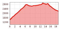
Route length: 19.6 km

A demanding tour for sure-footed and experienced trail runners, which literally takes you high up.
Tour information

  • Length: 19.6 km
  • Elevation uphill:2,218 hm
  • Elevation downhill:1,455 hm
Highest point2,973 m

Starting point

Nauders Parditsch

Finishing point

Bergkastel Bergstation
  • Fitness level 6 / 6
  • Technique 6 / 6

Best time of year

  • January
  • February
  • March
  • April
  • May
  • June
  • July
  • August
  • September
  • October
  • November
  • December
Source: TVB Tiroler Oberland

Description

Right from Nauders, the trail climbs steeply until, after a good 1,300 hm and 7 km, you reach the Gamorscharte and thus the ridge. You now follow it over numerous peaks. The view is magnificent, but a head for heights and surefootedness are of course a must! The highlight, the highest point, is the Großer
Schafkopf at just over 3,000 m! But the tour is not over yet, you still have to cross the Wölfeleskopf and Mataunkopf. Once you have reached the saddle after the Mataunkopf, the trail leads down to the destination, the Bergkastel, where you can round off this unique tour. The rest of the way down to the valley can then be done comfortably by gondola.

Weather

Today

clear sky
14°C/2°C
0%0l0 km/h

Wed

partly Cloudy
10°C/3°C
45%0.3l5 km/h

Thu

mainly clear
10°C/1°C
0%0l5 km/h
Go to weather forecast

More tours in the surrounding area

  • Sternenweg im Gepatsch

    Difficulty:medium
    Length:4.0 kmDuration:1:30 hElevation uphill:202 m
  • Rolli-Wanderung Aifner Alm

    Difficulty:medium
    Length:6.0 kmDuration:2:30 hElevation uphill:460 m
  • Rolli-Wanderung Nassereinalm

    Difficulty:medium
    Length:5.5 kmDuration:1:45 hElevation uphill:269 m
  • Rolli-Wanderung Gepatschhaus

    Length:8.5 kmDuration:1:45 hElevation uphill:156 m
  • Rolli-Wanderung Falkaunsalm

    Difficulty:medium
    Length:4.5 kmDuration:1:45 hElevation uphill:392 m
  • Handbike Route Kaunertaler Gletscher

    Difficulty:difficult
    Length:27.5 kmDuration:4:00 hElevation uphill:1,500 m
  • Talwanderweg Kaunertal

    Difficulty:easy
    Duration:2:30 hElevation uphill:295 m
  • Kaunerberger Wasserweg

    Opening hours:open
    Difficulty:medium
    Length:15.2 kmDuration:6:00 hElevation uphill:935 m
  • Hohe Aifnerspitze (2.779 m)

    Difficulty:medium
    Length:7.2 kmDuration:5:15 hElevation uphill:815 m
  • Gletscherlehrpfad Gepatschferner

    Difficulty:medium
    Length:8.4 kmDuration:3:45 hElevation uphill:400 m
  • Radurschlklamm Gorge

    Opening hours:open
    Difficulty:medium
    Length:7.5 kmDuration:3:20 hElevation uphill:442 m
  • Rundwanderung Frudiger

    Difficulty:medium
    Length:13.5 kmDuration:4:55 hElevation uphill:588 m
  • Kapelle Maria Schnee

    Difficulty:easy
    Length:1.7 kmDuration:0:30 hElevation uphill:90 m
  • Großer Mutzkopf

    Opening hours:closed
    Difficulty:easy
    Length:10.3 kmDuration:4:00 hElevation uphill:507 m
Newsletter

The mountain is calling? So does our newsletter!

In our monthly newsletter we reveal the best holiday tips for Tyrol.
