Mountain hikes Alpengasthof Feuerstein - Längenfeld/Huben

Längenfeld / Ötztaler Alpen
Difficulty ratings: easy
Route length: 3.0 km
Duration: 1:30 h

HUBEN FOOTBALL FIELD -> Forest path -> ALPENGASTHOF AM FEUERSTEIN

Tour information

  • Requirement: easy
  • Length: 3.0 km
  • Duration: 1:30 h
  • Elevation uphill:336 hm
  • Elevation downhill:0 hm
Highest point1,505 m

Starting point

Huben

Finishing point

Alpengasthof am Feuerstein
  • Fitness level 2 / 6

Best time of year

  • January
  • February
  • March
  • April
  • May
  • June
  • July
  • August
  • September
  • October
  • November
  • December

Equipment

Easy hiking trail; suitable for beginners and walkers. Please observe the current weather report.

Appropriate equipment such as breathable suitable outdoor clothes for the weather, ankle-high walking boots,

wind-, rain- & sun protection, hat, possibly gloves, is for all hikes and tours necessary.

Source: TVB Ötztal Tourismus

Description

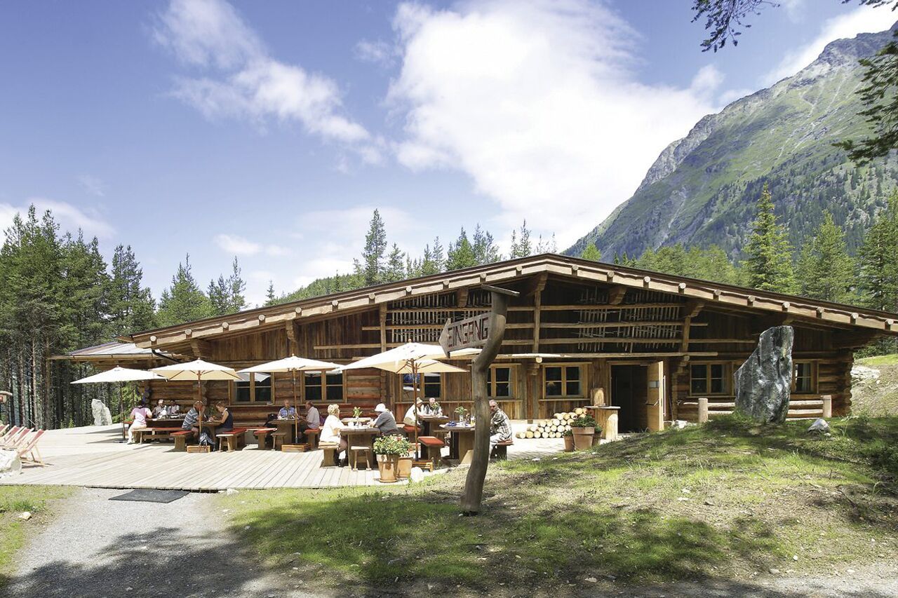
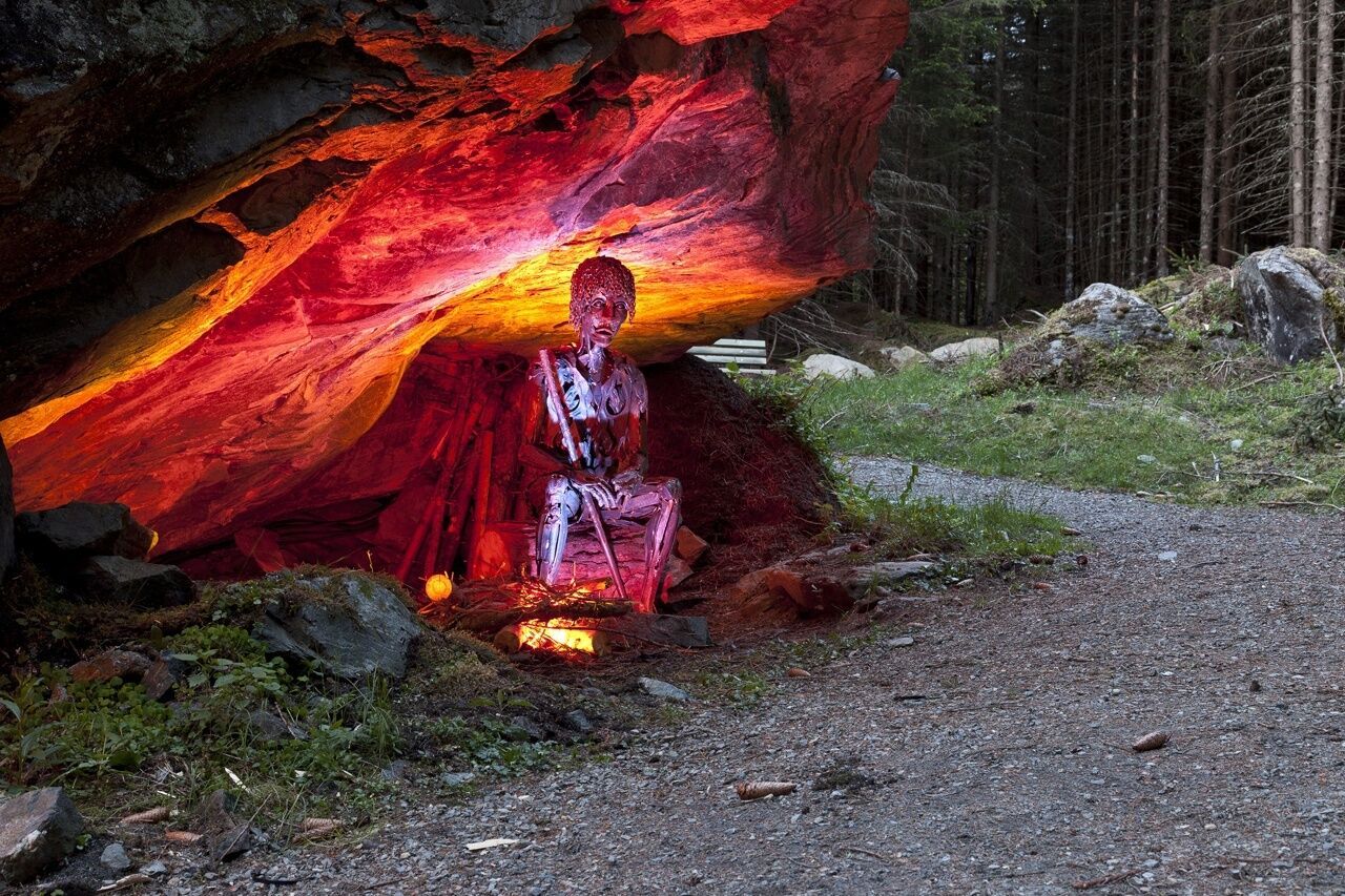
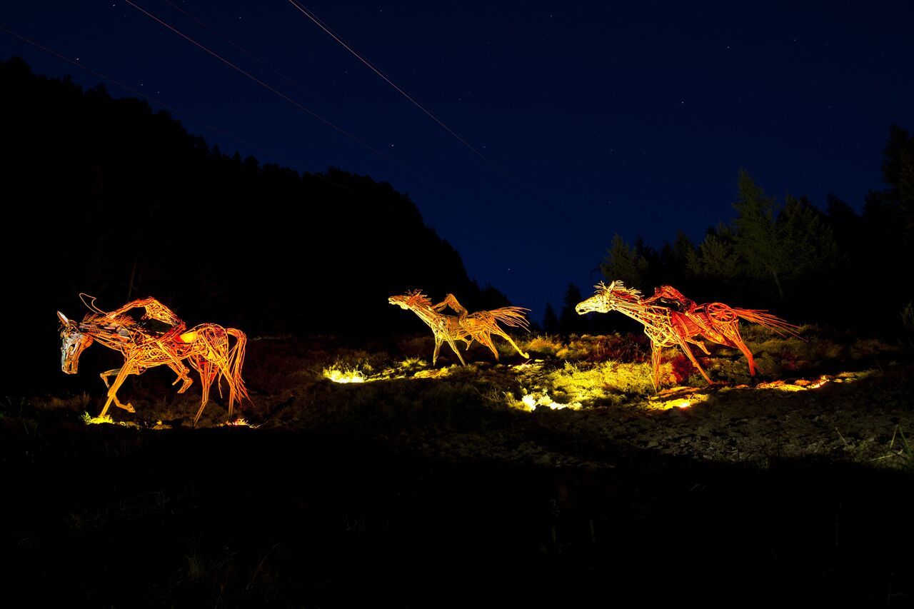
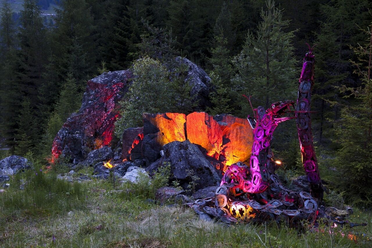
The Alpengasthof Feuerstein was newly built a few years ago. With plenty of extra wood in front and inside the hut, the building represents a piece of lived Ötztal tradition. Its interior skillfully bridges the gap between old and modern.The ascent starts on the forest path from the football field in Huben. Initially, it runs with a gentle incline. The last stretch just before the hut draws the last bit of strength out of you.The descent can be made via the Legend Trail. The family-friendly forest path surprises with metal sculptures up to six meters high:14 legends are recreated from scrap metal with life-sized and surprisingly lively figures. Plaques explain the respective legend, such as the fight of the giant, the wild Mandl, or the Angel's Wall.


Nearby huts and mountain restaurants

Getting here

  • Arrival by public transport

    Travel comfortably and safely by train. The final stop or departure point is the ÖTZTAL train station. Afterwards, you can conveniently and quickly travel through the entire valley to your desired destination by public transportation or local taxi companies.

    The current bus schedule is available at: http://fahrplan.vvt.at

  • Parking

    The following parking options are available in Huben:

    • Huben first entrance before Praxmarer carpentry – free of charge
    • Funpark Huben
    • Football field Huben

More tours in the surrounding area

  • Ötztal Trek Stage 6

    Difficulty: difficult
    Length: 7.6 km Duration: 3:30 h Elevation uphill: 640 m
  • Ötztal Trek Stage 7

    Difficulty: difficult
    Length: 5.3 km Duration: 2:00 h Elevation uphill: 376 m
  • Ötztal Trek Stage 17

    Difficulty: difficult
    Length: 16.4 km Duration: 6:00 h Elevation uphill: 1,080 m
  • Ötztal Trek Stage 16

    Difficulty: difficult
    Length: 6.9 km Duration: 2:30 h Elevation uphill: 358 m
  • Ötztal Trek Stage 4

    Difficulty: difficult
    Length: 8.9 km Duration: 4:00 h Elevation uphill: 802 m
  • Ötztal Trek Stage 3

    Difficulty: difficult
    Length: 10.4 km Duration: 4:00 h Elevation uphill: 842 m
  • Ötztal Trek Stage 1

    Difficulty: medium
    Length: 18.6 km Duration: 6:30 h Elevation uphill: 1,561 m
  • Ötztal Trek Stage 14

    Difficulty: difficult
    Length: 6.3 km Duration: 3:00 h Elevation uphill: 1,004 m
  • Ötztal Trek Stage 20

    Opening hours: closed
    Difficulty: medium
    Length: 6.4 km Duration: 3:00 h Elevation uphill: 610 m
  • Ötztal Trek Stage 12

    Difficulty: difficult
    Length: 4.8 km Duration: 2:00 h Elevation uphill: 592 m
  • Ötztaler Urweg

    Length: 189.1 km Duration: 72:19 h Elevation uphill: 9,428 m
  • Ötztal Trek Stage 22

    Difficulty: difficult
    Length: 21.5 km Duration: 8:00 h Elevation uphill: 647 m
  • Vent - Breslauer Hütte - Vernagthütte

    Difficulty: medium
    Length: 10.4 km Duration: 4:00 h Elevation uphill: 1,203 m
  • Ötztal Trek Stage 21

    Difficulty: difficult
    Length: 9.4 km Duration: 4:30 h Elevation uphill: 1,270 m
  • Ötztal Trek Stage 10

    Difficulty: difficult
    Length: 11.1 km Duration: 4:30 h Elevation uphill: 1,476 m
  • Ötztal Trek Stage 8

    Difficulty: difficult
    Length: 9.3 km Duration: 3:30 h Elevation uphill: 274 m
  • Ötztal Trek

    Length: 246.4 km Duration: 84:25 h Elevation uphill: 18,910 m
  • Ötztal Trek Stage 11

    Difficulty: difficult
    Length: 12.0 km Duration: 5:00 h Elevation uphill: 705 m
  • Ötztal Trek Stage 5

    Difficulty: difficult
    Length: 8.1 km Duration: 3:30 h Elevation uphill: 1,125 m
  • Mutsbühl

    Difficulty: medium
    Length: 4.5 km Duration: 1:30 h Elevation uphill: 470 m
  • Mountain peak Rosskopf

    Difficulty: medium
    Length: 2.0 km Duration: 2:00 h Elevation uphill: 379 m
Newsletter

The mountain is calling? So does our newsletter!

In our monthly newsletter we reveal the best holiday tips for Tyrol.