Mountain hikes Bergkastel via Taschaloch

Nauders / Ötztal Alps
Difficulty ratings: easy
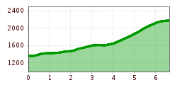
Route length: 6.7 km

Bergkastel via Taschaloch

Tour information

  • Requirement: easy
  • Length: 6.7 km
  • Elevation uphill:804 hm
  • Elevation downhill:0 hm

Starting point

Nauders Zentrum

Finishing point

Bergstation Bergkastelseilbahn
Source: TVB Tiroler Oberland

Description

The route goes along the Hiking trail no. 19 in the direction of the Holy Tree and shortly afterwards
to the right to the so-called “Stierhaag”. Trail no. 20 begins on the right-hand side and,
after crossing the Piengbach, leads across meadows and through forests towards Bergkastel.
It continues along the
Ganderbildbach through the narrow “Taschaloch”. You cross the forest path leading to the Jochelius
mountain resort, Piengalm or Stieralm. At the beginning the path is very steep, it is
somewhat flatter above the tree line. It leads to the foot of the Gande, where the Ganderbildbach
stream springs from several sources. To the west of it are the Bergkastel pastures and the
mountain station. The restaurant invites you to have some refreshments. To get back to the
village you can either take the cable car or walk over the Stieralm and the Almwanderweg (No.
34). The route can also be followed in the reverse direction.

Weather

Today

partly Cloudy
16°C/6°C
50%0.3l5 km/h

Sat

clear sky
19°C/4°C
0%0l5 km/h

Sun

mainly clear
20°C/6°C
30%0.7l5 km/h
Go to weather forecast

More tours in the surrounding area

  • Großer Mutzkopf

    Opening hours:closed
    Difficulty:easy
    Length:10.3 kmDuration:4:00 hElevation uphill:507 m
  • Ötztal Trek Stage 15

    Difficulty:difficult
    Length:6.5 kmDuration:2:30 hElevation uphill:332 m
  • Rolli-Wanderung Aifner Alm

    Difficulty:medium
    Length:6.0 kmDuration:2:30 hElevation uphill:460 m
  • Rolli-Wanderung Nassereinalm

    Difficulty:medium
    Length:5.5 kmDuration:1:45 hElevation uphill:269 m
  • Rolli-Wanderung Gepatschhaus

    Length:8.5 kmDuration:1:45 hElevation uphill:156 m
  • Rolli-Wanderung Falkaunsalm

    Difficulty:medium
    Length:4.5 kmDuration:1:45 hElevation uphill:392 m
  • Talwanderweg Kaunertal

    Difficulty:easy
    Duration:2:30 hElevation uphill:295 m
  • Kaunerberger Wasserweg

    Opening hours:closed
    Difficulty:medium
    Length:15.2 kmDuration:6:00 hElevation uphill:935 m
  • Gletscherlehrpfad Gepatschferner

    Difficulty:medium
    Length:8.4 kmDuration:3:45 hElevation uphill:400 m
  • Hohe Aifnerspitze (2.779 m)

    Difficulty:medium
    Length:7.2 kmDuration:5:15 hElevation uphill:815 m
  • Kapelle Maria Schnee

    Difficulty:easy
    Length:1.7 kmDuration:0:30 hElevation uphill:90 m
  • Radurschlklamm Gorge

    Opening hours:open
    Difficulty:medium
    Length:7.5 kmDuration:3:20 hElevation uphill:442 m
  • Rundwanderung Frudiger

    Difficulty:medium
    Length:13.5 kmDuration:4:55 hElevation uphill:588 m
  • Verpeilschlucht

    Opening hours:open
    Difficulty:medium
    Duration:3:00 hElevation uphill:386 m
Newsletter

The mountain is calling? So does our newsletter!

In our monthly newsletter we reveal the best holiday tips for Tyrol.