Mountain hikes Cable car hiking: Maria's Alm

Sölden / Ötztal Alps
Difficulty ratings: medium
Route length: 5.7 km
Duration: 2:00 h

Ascent with the GiggijochbahnHiking: Giggijochbahn mountain station - Hochsölden - Maria's Alm - Edelweißhütte - Sölden

Tour information

  • Requirement: medium
  • Length: 5.7 km
  • Duration: 2:00 h
  • Elevation uphill:4 hm
  • Elevation downhill:937 hm
Highest point2,280 m

Starting point

sölden

Finishing point

sölden
  • Fitness level 4 / 6

Best time of year

  • January
  • February
  • March
  • April
  • May
  • June
  • July
  • August
  • September
  • October
  • November
  • December
Source: TVB Ötztal Tourismus

Description

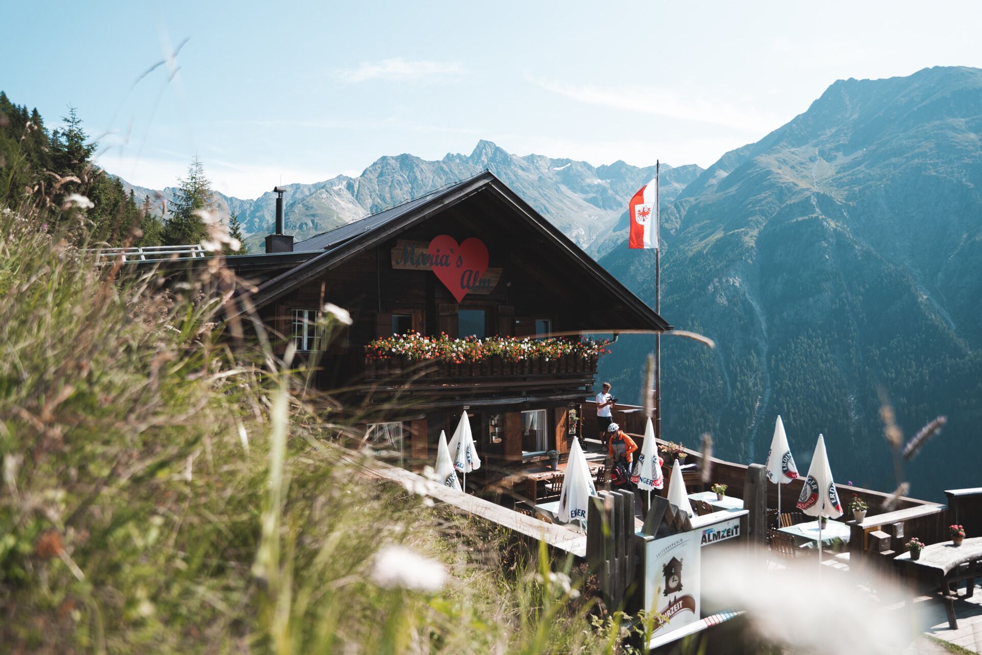
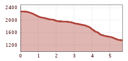
Ascent with the Giggijochbahn (2,284 m) - Descent to Hochsölden (2,083 m) - Hiking Maria's Alm (1,885 m) - Edelweißhütte (1,821 m) - Sölden


Nearby huts and mountain restaurants

Getting here

  • Arrival by public transport

    Travel comfortably and safely by train to Ötztal station. The final stop or exit point is the ÖTZTAL station. Afterwards, travel conveniently and quickly by public bus service or local taxis throughout the valley to your desired destination. The current bus schedule is available at: http://fahrplan.vvt.at

  • Parking

    The following parking options are available in Sölden:

    • Gaislachkoglbahn + underground garage

    The parking spaces are subject to a charge.

    For parking for several days (e.g., hut tour):

    • Parking garage Gaislachkoglbahn, parking ticket either online or directly at the Gaislachkoglbahn ticket office

More tours in the surrounding area

  • Ötztal Trek Stage 4

    Difficulty:difficult
    Length:8.9 kmDuration:4:00 hElevation uphill:802 m
  • Ötztal Trek Stage 3

    Difficulty:difficult
    Length:10.4 kmDuration:4:00 hElevation uphill:842 m
  • Ötztal Trek Stage 10

    Difficulty:difficult
    Length:11.1 kmDuration:4:30 hElevation uphill:1,476 m
  • Ötztal Trek

    Length:246.4 kmDuration:84:25 hElevation uphill:18,910 m
  • Ötztal Trek Stage 16

    Difficulty:difficult
    Length:6.9 kmDuration:2:30 hElevation uphill:358 m
  • Ötztal Trek Stage 11

    Difficulty:difficult
    Length:12.0 kmDuration:5:00 hElevation uphill:705 m
  • Ötztal Trek Stage 5

    Difficulty:difficult
    Length:8.1 kmDuration:3:30 hElevation uphill:1,125 m
  • Ötztal Trek Stage 6

    Difficulty:difficult
    Length:7.6 kmDuration:3:30 hElevation uphill:640 m
  • Ötztal Trek Stage 8

    Difficulty:difficult
    Length:9.3 kmDuration:3:30 hElevation uphill:274 m
  • Ötztal Trek Stage 1

    Difficulty:medium
    Length:18.6 kmDuration:6:30 hElevation uphill:1,561 m
  • Ötztal Trek Stage 14

    Difficulty:difficult
    Length:6.3 kmDuration:3:00 hElevation uphill:1,004 m
  • Ötztal Trek Stage 20

    Opening hours:closed
    Difficulty:medium
    Length:6.4 kmDuration:3:00 hElevation uphill:610 m
  • Ötztal Trek Stage 12

    Difficulty:difficult
    Length:4.8 kmDuration:2:00 hElevation uphill:592 m
  • Ötztal Trek Stage 7

    Difficulty:difficult
    Length:5.3 kmDuration:2:00 hElevation uphill:376 m
  • Ötztal Trek Stage 17

    Difficulty:difficult
    Length:16.4 kmDuration:6:00 hElevation uphill:1,080 m
  • Ötztaler Urweg

    Length:189.1 kmDuration:72:19 hElevation uphill:9,428 m
  • Ötztal Trek Stage 22

    Difficulty:difficult
    Length:21.5 kmDuration:8:00 hElevation uphill:647 m
  • Ötztal Trek Stage 21

    Difficulty:difficult
    Length:9.4 kmDuration:4:30 hElevation uphill:1,270 m
  • Mutsbühl

    Difficulty:medium
    Length:4.5 kmDuration:1:30 hElevation uphill:470 m
Newsletter

The mountain is calling? So does our newsletter!

In our monthly newsletter we reveal the best holiday tips for Tyrol.