Mountain hikes Frischmann hut - Umhausen

Umhausen / Ötztal Alps
Difficulty ratings: easy
Route length: 10.3 km
Duration: 4:09 h

UMHAUSEN -> Mure parking lot -> district Neudorf -> Fundus bridge -> Fundustal/Leierstal crossroads -> Front Fundusalm -> Rear Fundusalm -> FRISCHMANNS HUT

Tour information

  • Requirement: easy
  • Length: 10.3 km
  • Duration: 4:09 h
  • Elevation uphill:1,216 hm
  • Elevation downhill:51 hm
Highest point2,195 m

Starting point

Mure parking lot

Finishing point

Frischmann hut
  • Fitness level 2 / 6

Best time of year

  • January
  • February
  • March
  • April
  • May
  • June
  • July
  • August
  • September
  • October
  • November
  • December

Equipment

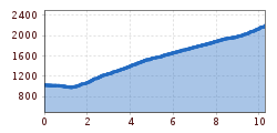
Medium difficulty hiking trail; endurance required

Please note the current weather report

Appropriate equipment such as breathable and weather-appropriate outdoor clothing, ankle-high hiking boots, wind, rain and sun protection, hat, possibly gloves, is required for all hikes and routes. Carrying a first aid kit, a mobile phone and possibly a hiking map, as well as enough provisions for hikes without catering options, is necessary.

Source: TVB Ötztal Tourismus

Description

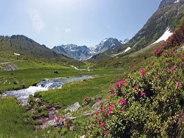
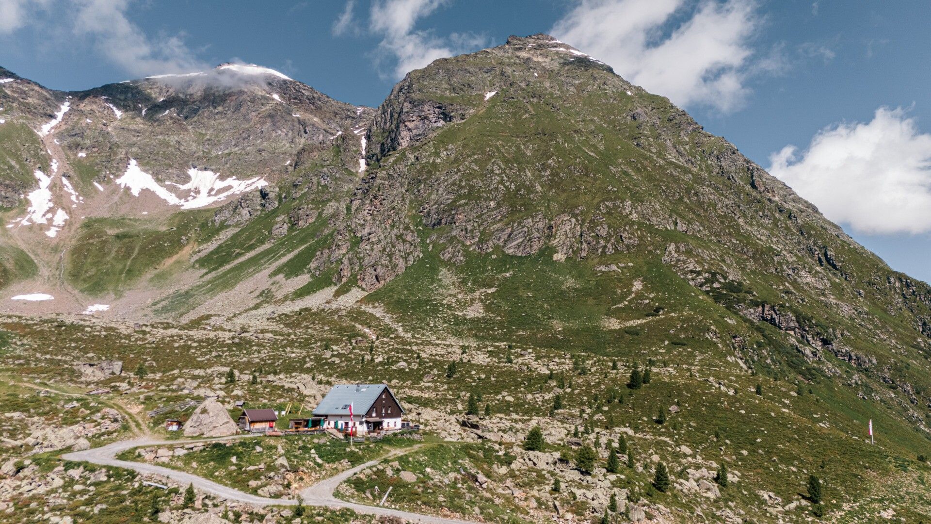
From the Mure parking lot in the village center of Umhausen, you walk leisurely through the district of Neudorf. After crossing the Fundus bridge, follow the wide forest road to the Fundustal (left) and Leierstal (right) crossroads. You walk along the wide forest road towards Fundustal, past the Front Fundusalm (not managed) and then continue to the Rear Fundusalm. The Fundustal in the eastern Ötztal Alps lies lonely and remote high above Umhausen. The solitude and the beauty of nature can be wonderfully enjoyed here. Green meadows and the crystal-clear Fundus lake invite you to linger on a hot summer day. From the Rear Fundusalm, you can comfortably hike along the forest road in 30 minutes to the Frischmann hut. There is also the option to return from the Rear Fundusalm to Umhausen by hut taxi.

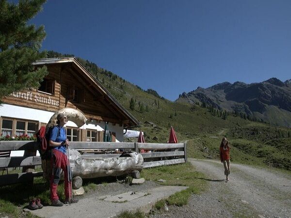
The Frischmann hut belongs to the Genussplatzlen. "Regional, seasonal, honest cuisine – whatever is available is enough!"– is the motto. The Genussplatzlen includes dedicated businesses that act regionally & sustainably whenever possible. Learn more at www.oetztal.com/genussplatzlen


Nearby huts and mountain restaurants

Getting here

  • Arrival by public transport

    Travel comfortably and safely by train to the Ötztal train station. The final stop or exit point is ÖTZTAL station. Afterwards, you travel conveniently and quickly by public transport or local taxi companies through the entire valley to your desired destination! The current bus schedule is available at: http://fahrplan.vvt.at

  • Parking

    In Umhausen, the following parking options are available:

    • Mure parking lot | free of charge

More tours in the surrounding area

  • Ötztal Trek Stage 4

    Difficulty:difficult
    Length:8.9 kmDuration:4:00 hElevation uphill:802 m
  • Ötztal Trek Stage 10

    Difficulty:difficult
    Length:11.1 kmDuration:4:30 hElevation uphill:1,476 m
  • Ötztal Trek Stage 8

    Difficulty:difficult
    Length:9.3 kmDuration:3:30 hElevation uphill:274 m
  • Ötztal Trek

    Length:246.4 kmDuration:84:25 hElevation uphill:18,910 m
  • Ötztal Trek Stage 16

    Difficulty:difficult
    Length:6.9 kmDuration:2:30 hElevation uphill:358 m
  • Ötztal Trek Stage 20

    Difficulty:medium
    Length:6.4 kmDuration:3:00 hElevation uphill:610 m
  • Ötztal Trek Stage 11

    Difficulty:difficult
    Length:12.0 kmDuration:5:00 hElevation uphill:705 m
  • Ötztal Trek Stage 5

    Difficulty:difficult
    Length:8.1 kmDuration:3:30 hElevation uphill:1,125 m
  • Ötztal Trek Stage 6

    Difficulty:difficult
    Length:7.6 kmDuration:3:30 hElevation uphill:640 m
  • Ötztal Trek Stage 7

    Difficulty:difficult
    Length:5.3 kmDuration:2:00 hElevation uphill:376 m
  • Ötztal Trek Stage 17

    Difficulty:difficult
    Length:16.4 kmDuration:6:00 hElevation uphill:1,080 m
  • Ötztal Trek Stage 12

    Difficulty:difficult
    Length:4.8 kmDuration:2:00 hElevation uphill:592 m
  • Ötztal Trek Stage 21

    Difficulty:difficult
    Length:9.4 kmDuration:4:30 hElevation uphill:1,270 m
  • Ötztal Trek Stage 3

    Difficulty:difficult
    Length:10.4 kmDuration:4:00 hElevation uphill:842 m
  • Ötztal Trek Stage 1

    Difficulty:medium
    Length:18.6 kmDuration:6:30 hElevation uphill:1,561 m
  • Ötztal Trek Stage 14

    Difficulty:difficult
    Length:6.3 kmDuration:3:00 hElevation uphill:1,004 m
  • Ötztaler Urweg

    Length:189.1 kmDuration:72:19 hElevation uphill:9,428 m
  • Ötztal Trek Stage 22

    Difficulty:difficult
    Length:21.5 kmDuration:8:00 hElevation uphill:647 m
  • Stuibenfall hike - Umhausen

    Opening hours:open
    Difficulty:easy
    Length:2.9 kmDuration:1:45 hElevation uphill:456 m
  • Piccard bridge loop hike - Obergurgl

    Opening hours:closed
    Difficulty:difficult
    Length:18.2 kmDuration:8:00 hElevation uphill:1,111 m
Newsletter

The mountain is calling? So does our newsletter!

In our monthly newsletter we reveal the best holiday tips for Tyrol.