Kalvarienberg

Ried im Oberinntal / Ötztal Alps
Difficulty ratings: easy
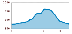
Route length: 3.5 km
Duration: 1:00 h

Pleasant walking path to Kalvarienberg in Ried in the Upper Inn Valley.

Tour information

  • Requirement: easy
  • Length: 3.5 km
  • Duration: 1:00 h
  • Elevation uphill:89 hm
  • Elevation downhill:82 hm
Highest point966 m

Starting point

Infobüro TVB | Ried im Oberinntal

Finishing point

Infobüro TVB | Ried im Oberinntal
  • Fitness level 1 / 6
  • Technique 1 / 6

Features

  • Circular route
  • Suitable for families

Best time of year

  • January
  • February
  • March
  • April
  • May
  • June
  • July
  • August
  • September
  • October
  • November
  • December

Equipment

We recommend equipment suitable for the tour and weather conditions, including sturdy shoes, weatherproof clothing, food, and appropriate maps.
Source: TVB Tiroler Oberland

Description

The circular walk starts at the information office in Ried in the Upper Inn Valley and initially leads to the southern edge of the village. There, one turns left and follows a scenic path that runs across meadows and along the edge of the forest until reaching the paved path in the Langwiese. After about 100 meters, a forest trail branches off sharply to the left and leads up to the Kalvarienberg with its impressive carved Stations of the Cross. From therethe way leads back to Ried.

Weather

Today

light rain showers
19°C/8°C
60%0.9l5 km/h

Sat

clear sky
22°C/7°C
0%0l5 km/h

Sun

clear sky
23°C/8°C
55%0.9l5 km/h
Go to weather forecast

More tours in the surrounding area

  • Großer Mutzkopf

    Opening hours:closed
    Difficulty:easy
    Length:10.3 kmDuration:4:00 hElevation uphill:507 m
  • Ötztal Trek Stage 15

    Difficulty:difficult
    Length:6.5 kmDuration:2:30 hElevation uphill:332 m
  • Rolli-Wanderung Aifner Alm

    Difficulty:medium
    Length:6.0 kmDuration:2:30 hElevation uphill:460 m
  • Rolli-Wanderung Nassereinalm

    Difficulty:medium
    Length:5.5 kmDuration:1:45 hElevation uphill:269 m
  • Rolli-Wanderung Gepatschhaus

    Length:8.5 kmDuration:1:45 hElevation uphill:156 m
  • Rolli-Wanderung Falkaunsalm

    Difficulty:medium
    Length:4.5 kmDuration:1:45 hElevation uphill:392 m
  • Talwanderweg Kaunertal

    Difficulty:easy
    Duration:2:30 hElevation uphill:295 m
  • Kaunerberger Wasserweg

    Opening hours:closed
    Difficulty:medium
    Length:15.2 kmDuration:6:00 hElevation uphill:935 m
  • Gletscherlehrpfad Gepatschferner

    Difficulty:medium
    Length:8.4 kmDuration:3:45 hElevation uphill:400 m
  • Hohe Aifnerspitze (2.779 m)

    Difficulty:medium
    Length:7.2 kmDuration:5:15 hElevation uphill:815 m
  • Kapelle Maria Schnee

    Difficulty:easy
    Length:1.7 kmDuration:0:30 hElevation uphill:90 m
  • Radurschlklamm Gorge

    Opening hours:open
    Difficulty:medium
    Length:7.5 kmDuration:3:20 hElevation uphill:442 m
  • Rundwanderung Frudiger

    Difficulty:medium
    Length:13.5 kmDuration:4:55 hElevation uphill:588 m
  • Verpeilschlucht

    Opening hours:open
    Difficulty:medium
    Duration:3:00 hElevation uphill:386 m
Newsletter

The mountain is calling? So does our newsletter!

In our monthly newsletter we reveal the best holiday tips for Tyrol.