Mountain hikes Nach Pfunds von der Labaunalm

open
Nauders / Ötztal Alps
Difficulty ratings: medium
Route length: 11.7 km
Duration: 6:00 h

Nach Pfunds von der Labaunalm

Tour information

  • Requirement: medium
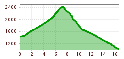
  • Length: 11.7 km
  • Duration: 6:00 h
  • Elevation uphill:475 hm
  • Elevation downhill:1,432 hm
Highest point2,400 m

Starting point

Labaunalm

Finishing point

Pfunds Dorf
Source: TVB Tiroler Oberland

Description

With the hiking taxi you first travel from Nauders to Labaunalm. Trail no. 14 leads to the Saderer Joch. Continue on Route no. 26, along the Sadresbach, down to the “Kaltenwirt” (approx. 1,460 m). From here you follow Trail no. 9 over the romantic, well-worth seeing gorge path to the village. When you arrive in Pfunds, you can take the Post bus back to Nauders.

Weather

Today

mainly clear
27°C/11°C
5%0l5 km/h

Wed

light rain showers
27°C/14°C
55%7.1l5 km/h

Thu

mainly clear
30°C/13°C
0%0l5 km/h
Go to weather forecast

More tours in the surrounding area

Newsletter

The mountain is calling? So does our newsletter!

In our monthly newsletter we reveal the best holiday tips for Tyrol.