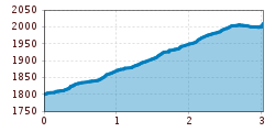
Open interactive mapOpen this POI on the interactive mapElevation profiledownloadRolli-Wanderung Reschner Alm.gpx
Lämmerbichl_Tirol Werbung_Sürth Paul_Tux-Hintertux.jpg © Sürth Paul Spring with late crocus blossom in Tux ValleyDifficulty:mediumLength:10.0 kmDuration:4:00 hElevation uphill:640 mSee trailSee trail: Spring with late crocus blossom in Tux Valley
Round hike to Padauner KogelDifficulty:mediumLength:12.0 kmDuration:5:00 hElevation uphill:936 mSee trailSee trail: Round hike to Padauner Kogel
Geraerhütte_JohannesBitter_TVB-Wipptal_170623_105.jpg © JOHANNES BITTER Hike to the Geraer Hütte | Austrian TyrolDifficulty:mediumLength:7.0 kmDuration:5:30 hElevation uphill:1,000 mSee trailSee trail: Hike to the Geraer Hütte | Austrian Tyrol
©-TVB-Tiroler-Oberland-Kaunertal-Michael-Veit-Klima-Führer-2018-Gepatsch-Nasserein © Michael Veit Sternenweg im GepatschDifficulty:mediumLength:4.0 kmDuration:1:30 hElevation uphill:202 mSee trailSee trail: Sternenweg im Gepatsch
2023_TVB-Ischgl-Paznaun_Sommer_Cross-Trail_Gruebele-See_WEST_3267.jpg © TVB Paznaun-Ischgl 01 Premium long-distance hiking trail - High route PaznaunDifficulty:mediumLength:138.6 kmDuration:10 daysElevation uphill:10,316 mSee trailSee trail: 01 Premium long-distance hiking trail - High route Paznaun
Etappe_6 (1).jpg © Tourismusverband Paznaun - Ischgl Stage 6: Through the VerwallDifficulty:mediumLength:15.0 kmDuration:8:00 hElevation uphill:1,481 mSee trailSee trail: Stage 6: Through the Verwall
Sonnenuntergang auf der Gratlspitze - Aussichtsbank © T. Mühlbacher Gratlspitze 1.899 m - starting point: Berggasthof HolzalmDifficulty:mediumLength:4.6 kmDuration:2:30 hElevation uphill:479 mSee trailSee trail: Gratlspitze 1.899 m - starting point: Berggasthof Holzalm
Ehrenberg Castle World - Schlosskopf © Lea Zotz Barrier-free theme trail at the castle headDifficulty:easyLength:1.0 kmDuration:0:20 hElevation uphill:26 mSee trailSee trail: Barrier-free theme trail at the castle head
valentinkapelle-1.jpg © Archiv TVB Mayrhofen Mountain hike: Zillergrund - Valentins KapelleDifficulty:mediumLength:3.2 kmDuration:2:30 hElevation uphill:390 mSee trailSee trail: Mountain hike: Zillergrund - Valentins Kapelle
Erlanger Hütte © Ötztal Ötztal Trek Stage 22Difficulty:difficultLength:21.5 kmDuration:8:00 hElevation uphill:647 mSee trailSee trail: Ötztal Trek Stage 22
Hütte.jpg © (c) Serfaus-Fiss-Ladis Marketing GmbH_Andreas Kirschner Panorama - GenusswegOpening hours:openDifficulty:easyLength:5.1 kmDuration:1:15 hElevation uphill:42 mSee trailSee trail: Panorama - Genussweg
vent - breslauer hütte - vernagthütte_img_23330472 © Katharina Schatz Vent - Breslauer Hütte - VernagthütteDifficulty:mediumLength:10.4 kmDuration:4:00 hElevation uphill:1,203 mSee trailSee trail: Vent - Breslauer Hütte - Vernagthütte
Apfelmeile © Katharina Schatz Ötztaler UrwegDifficulty:difficultLength:177.2 kmDuration:60:49 hElevation uphill:7,541 mSee trailSee trail: Ötztaler Urweg
ötztal trek etappe 21_img_27378494 © Katharina Schatz Ötztal Trek Stage 21Difficulty:difficultLength:9.4 kmDuration:4:30 hElevation uphill:1,270 mSee trailSee trail: Ötztal Trek Stage 21
2018-Wandern-Bergsteigen-Tarrenz-Sinnesbrunn-Alpleskopf-web-©Rudi Wyhlidal (60).jpg © Rudi Wyhlidal / WEST - Kollreider falscher KogelDifficulty:difficultLength:1.7 kmDuration:2:30 hElevation uphill:364 mSee trailSee trail: falscher Kogel
gipfeltour rosskopf_img_39972994 © Ötztal Tourismus Büro Oetz Mountain peak RosskopfDifficulty:mediumLength:2.0 kmDuration:2:00 hElevation uphill:379 mSee trailSee trail: Mountain peak Rosskopf
Wandern © Bernd Ritschel Narrenkogel - NiederthaiDifficulty:mediumLength:2.9 kmDuration:2:00 hElevation uphill:764 mSee trailSee trail: Narrenkogel - Niederthai
hochstubaihütte über seekarsee & himmelsleiter - sölden_img_56888636 © Ötztal Hochstubaihütte über Seekarsee & Himmelsleiter - SöldenDifficulty:difficultLength:4.8 kmDuration:4:00 hElevation uphill:1,270 mSee trailSee trail: Hochstubaihütte über Seekarsee & Himmelsleiter - Sölden
Barrierefreie Dorfrunde Scharnitz © JACKSCORNER Wheelchair Hike Scharnitz–GießenbachDifficulty:easyLength:7.0 kmDuration:1:50 hElevation uphill:40 mSee trailSee trail: Wheelchair Hike Scharnitz–Gießenbach
Leutascher Ache im Herbst © Region Seefeld Wheelchair Circular Hike Kirchplatzl-AchwegDifficulty:easyLength:1.8 kmDuration:0:30 hElevation uphill:10 mSee trailSee trail: Wheelchair Circular Hike Kirchplatzl-Achweg
Pfarrkirche und Ganghofermuseum Leutasch © Region Seefeld Wheelchair Circular Hike Runst-AchwegDifficulty:easyLength:6.3 kmDuration:2:00 hElevation uphill:40 mSee trailSee trail: Wheelchair Circular Hike Runst-Achweg
Kaufbeurer Haus © Lechtal Tourismus Hinterhornbach - Kaufbeurer HausDifficulty:mediumLength:3.4 kmElevation uphill:923 mSee trailSee trail: Hinterhornbach - Kaufbeurer Haus
Bach - Memminger HütteDifficulty:mediumLength:13.6 kmDuration:5:45 hElevation uphill:1,229 mSee trailSee trail: Bach - Memminger Hütte
Lermoos - Moosles ForscherpfadOpening hours:openDifficulty:easyLength:2.7 kmDuration:1:00 hSee trailSee trail: Lermoos - Moosles Forscherpfad
IMG_20190716_162017.jpg © Nina Falger Berwang - Abendspitze & GaltjochDifficulty:mediumLength:5.8 kmDuration:6:00 hElevation uphill:991 mSee trailSee trail: Berwang - Abendspitze & Galtjoch
Give feedback for a chance to win a special holiday experience!Click here for the surveyClick here for the survey