Snowshoe hike Snowshoe Trail Acherkogelblick 02

Oetz / Stubaier Alpen
Difficulty ratings: medium
Route length: 3.4 km
Duration: 2:00 h

ACHERKOGELBAHN -> Rotes Wandl -> Acherkogelblick Viewing Platform -> ACHERKOGELBAHN

Tour information

  • Requirement: medium
  • Length: 3.4 km
  • Duration: 2:00 h
  • Elevation uphill:89 hm
  • Elevation downhill:89 hm
Highest point2,016 m

Starting point

Panoramic Restaurant Hochoetz

Finishing point

Panoramic Restaurant Hochoetz
  • Fitness level 3 / 6

Best time of year

  • January
  • February
  • March
  • April
  • May
  • June
  • July
  • August
  • September
  • October
  • November
  • December

Equipment

Please note the current snow and avalanche report for the coming days: www.oetztal.com/en/winter.html & avalanche.report/albina-web/bulletin/2019-01-07

Appropriate equipment such as breathable and weather-appropriate outdoor clothing, wind, rain, snow, and sun protection, hat and gloves is required for all hikes and routes. Carrying a first aid kit, a mobile phone, and possibly a route map, as well as sufficient provisions for tours without places to stop, is necessary.

Source: Ötztal

Description

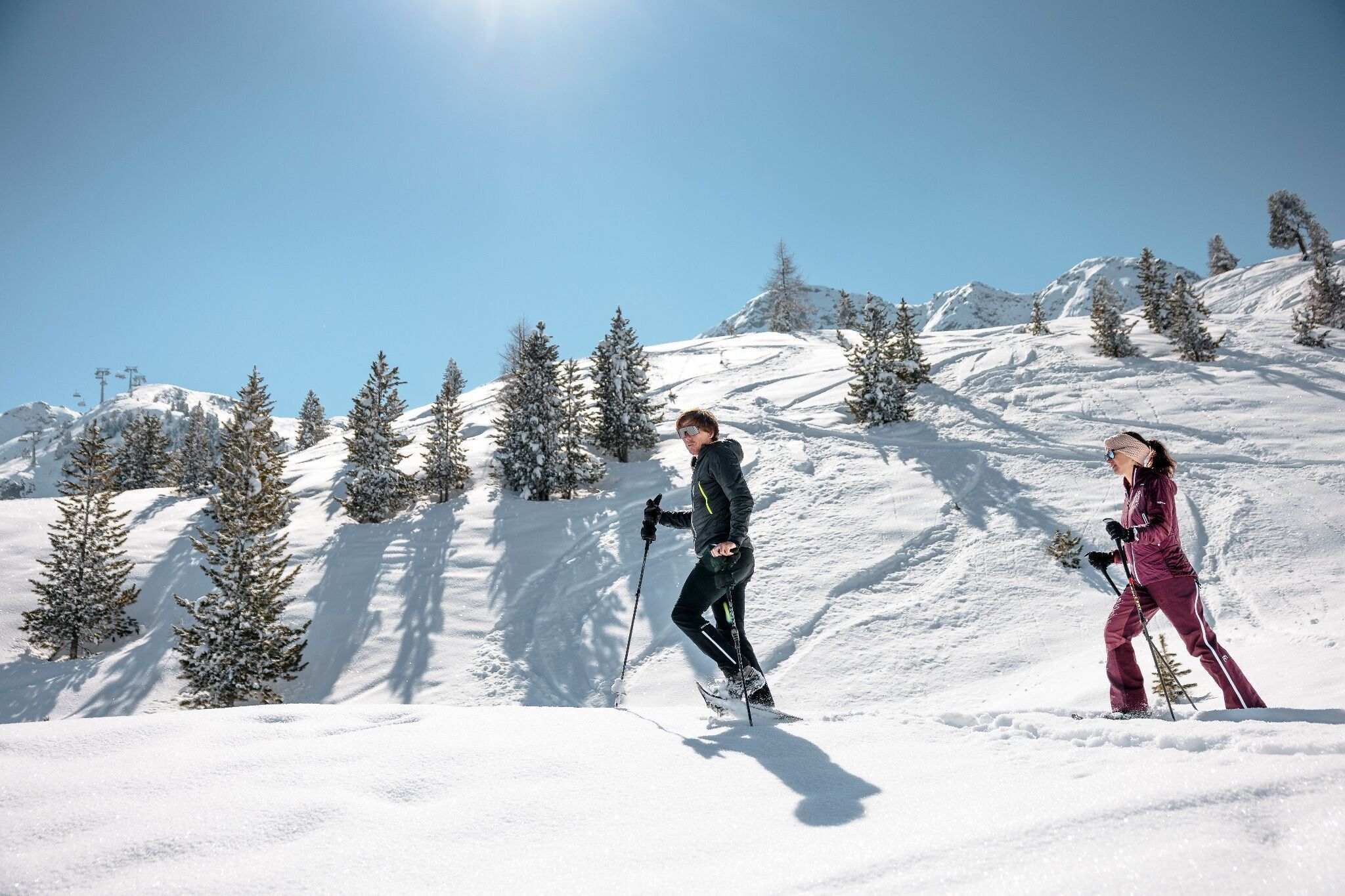
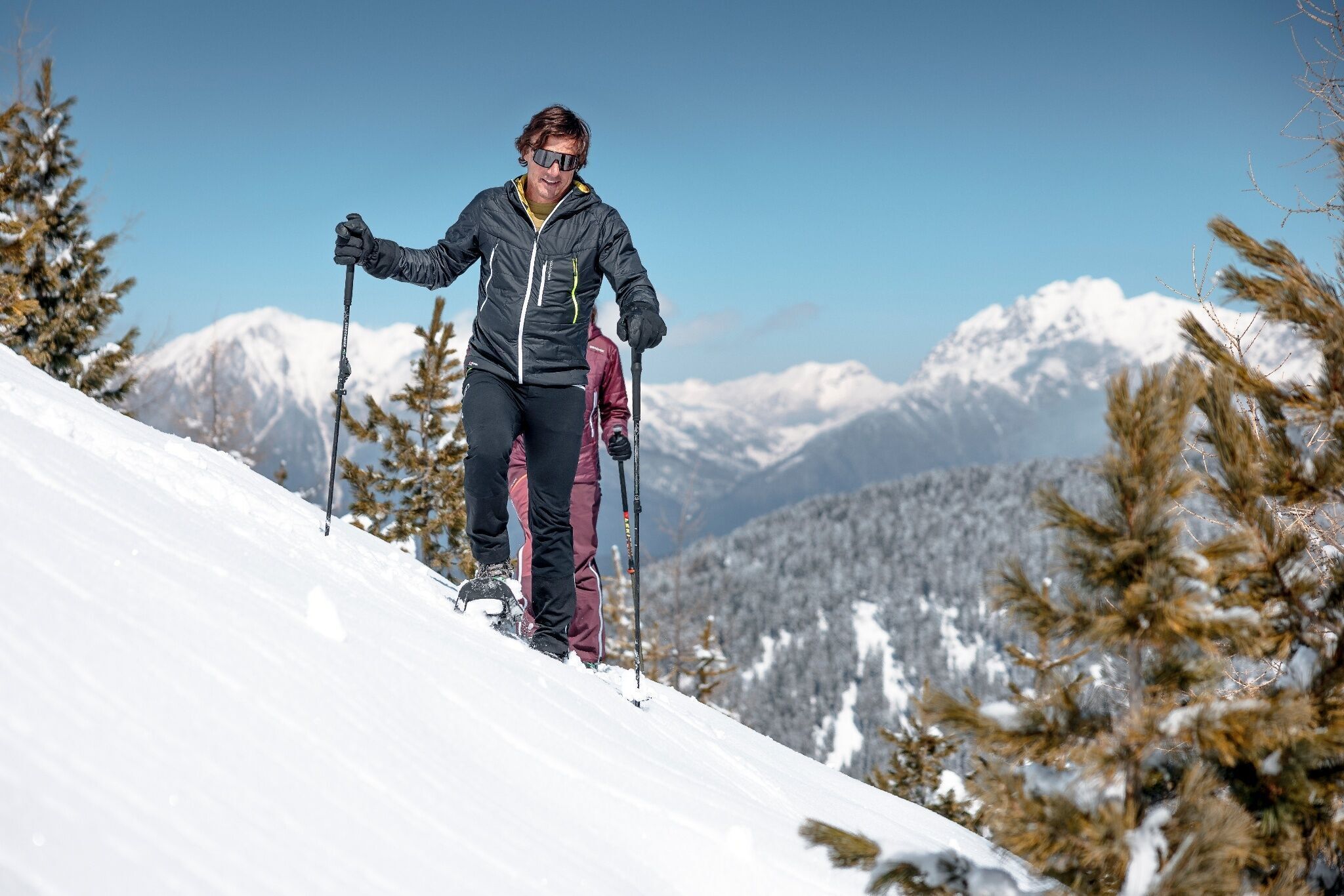
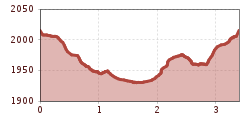
You take the Acherkogelbahn into the Hochoetz ski region. The beautiful, signposted snowshoe trail starts below the panoramic restaurant (2020 m) and leads off-piste to the Rotes Wandl, then gently downhill through the snow-covered winter forest to the Acherkogelblick viewing platform. The impressive view of the Acherkogel invites you to linger. On the way back, the kilometers covered must always be ascended slightly.


Nearby huts and mountain restaurants

Getting here

  • Arrival by public transport

    Travel comfortably and safely by train to Ötztal station. At the station, you will find public transport or local taxi companies that will be happy to take you to your desired destination! The current bus schedule is available at: http://fahrplan.vvt.at

  • Parking

    The following parking options are available:

    • Acherkogelbahn parking lot (paid)
    • Rafting entry point parking lot (at the end of Oetz on the right side) (paid)
    • Oetz center parking lot (paid)
    • Overnight parking during multi-day tours: Oetz center parking lot, tickets are available at the Oetz information office.

More tours in the surrounding area

  • Ötztal Trek Stage 6

    Difficulty: difficult
    Length: 7.6 km Duration: 3:30 h Elevation uphill: 640 m
  • Ötztal Trek Stage 8

    Difficulty: difficult
    Length: 9.3 km Duration: 3:30 h Elevation uphill: 274 m
  • Ötztal Trek Stage 17

    Difficulty: difficult
    Length: 16.4 km Duration: 6:00 h Elevation uphill: 1,080 m
  • Ötztal Trek Stage 16

    Difficulty: difficult
    Length: 6.9 km Duration: 2:30 h Elevation uphill: 358 m
  • Ötztal Trek Stage 20

    Opening hours: closed
    Difficulty: medium
    Length: 6.4 km Duration: 3:00 h Elevation uphill: 610 m
  • Ötztal Trek Stage 5

    Difficulty: difficult
    Length: 8.1 km Duration: 3:30 h Elevation uphill: 1,125 m
  • Winter hiking trail Rotes Wandl - No. 431

    Opening hours: closed
    Difficulty: easy
    Length: 1.5 km Duration: 0:45 h Elevation uphill: 52 m
  • Ötztal Trek Stage 4

    Difficulty: difficult
    Length: 8.9 km Duration: 4:00 h Elevation uphill: 802 m
  • Ötztal Trek Stage 3

    Difficulty: difficult
    Length: 10.4 km Duration: 4:00 h Elevation uphill: 842 m
  • Ötztal Trek Stage 10

    Difficulty: difficult
    Length: 11.1 km Duration: 4:30 h Elevation uphill: 1,476 m
  • Ötztal Trek

    Length: 246.4 km Duration: 84:25 h Elevation uphill: 18,910 m
  • Ötztal Trek Stage 1

    Difficulty: medium
    Length: 18.6 km Duration: 6:30 h Elevation uphill: 1,561 m
  • Ötztal Trek Stage 14

    Difficulty: difficult
    Length: 6.3 km Duration: 3:00 h Elevation uphill: 1,004 m
  • Ötztal Trek Stage 11

    Difficulty: difficult
    Length: 12.0 km Duration: 5:00 h Elevation uphill: 705 m
  • Ötztaler Urweg

    Length: 189.1 km Duration: 72:19 h Elevation uphill: 9,428 m
  • Ötztal Trek Stage 7

    Difficulty: difficult
    Length: 5.3 km Duration: 2:00 h Elevation uphill: 376 m
  • Ötztal Trek Stage 12

    Difficulty: difficult
    Length: 4.8 km Duration: 2:00 h Elevation uphill: 592 m
  • Ötztal Trek Stage 22

    Difficulty: difficult
    Length: 21.5 km Duration: 8:00 h Elevation uphill: 647 m
  • Ötztal Trek Stage 21

    Difficulty: difficult
    Length: 9.4 km Duration: 4:30 h Elevation uphill: 1,270 m
  • Vent - Breslauer Hütte - Vernagthütte

    Difficulty: medium
    Length: 10.4 km Duration: 4:00 h Elevation uphill: 1,203 m
Newsletter

The mountain is calling? So does our newsletter!

In our monthly newsletter we reveal the best holiday tips for Tyrol.