Themed hikes Wunderpfad Herrensteig

open
Ried im Oberinntal / Ötztal Alps
Difficulty ratings: easy
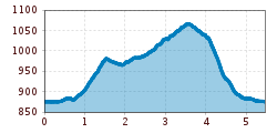
Route length: 5.5 km
Duration: 1:54 h

Lumos lost light

Tour information

  • Requirement: easy
  • Length: 5.5 km
  • Duration: 1:54 h
  • Elevation uphill:211 hm
  • Elevation downhill:206 hm
Highest point1,067 m

Starting point

Infobüro TVB | Ried im Oberinntal

Finishing point

Infobüro TVB | Ried im Oberinntal
  • Fitness level 2 / 6
  • Technique 2 / 6

Best time of year

  • January
  • February
  • March
  • April
  • May
  • June
  • July
  • August
  • September
  • October
  • November
  • December

Trail condition

trail, asphalt

Equipment

We recommend equipment suitable for the tour and weather conditions, including sturdy shoes, weatherproof clothing, food, and appropriate maps.
Source: TVB Tiroler Oberland

Description

Exciting stories, small puzzles, and playful challenges about the memories of the Herrensteig await you on your smartphone. Collect lost keepsakes at 14 stations and help Lumo bring his light back, piece by piece. Scan the QR code now and start exploring!
Click here for the digital "Wunderpfad": https://app.wunderweg.com/tiroler-oberland

Getting here

  • Arrival by public transport

    Line 210, 220, Bus stop: Ried i. O. Gemeindeamt, walking distance to the tourist information office: 200 m

  • Parking

    Parking area at the lake, free of charge

Weather

Today

light rain showers
19°C/8°C
60%0.9l5 km/h

Sat

clear sky
22°C/7°C
0%0l5 km/h

Sun

clear sky
23°C/8°C
55%0.9l5 km/h
Go to weather forecast

More tours in the surrounding area

  • Großer Mutzkopf

    Opening hours:closed
    Difficulty:easy
    Length:10.3 kmDuration:4:00 hElevation uphill:507 m
  • Ötztal Trek Stage 15

    Difficulty:difficult
    Length:6.5 kmDuration:2:30 hElevation uphill:332 m
  • Rolli-Wanderung Aifner Alm

    Difficulty:medium
    Length:6.0 kmDuration:2:30 hElevation uphill:460 m
  • Rolli-Wanderung Nassereinalm

    Difficulty:medium
    Length:5.5 kmDuration:1:45 hElevation uphill:269 m
  • Rolli-Wanderung Gepatschhaus

    Length:8.5 kmDuration:1:45 hElevation uphill:156 m
  • Rolli-Wanderung Falkaunsalm

    Difficulty:medium
    Length:4.5 kmDuration:1:45 hElevation uphill:392 m
  • Talwanderweg Kaunertal

    Difficulty:easy
    Duration:2:30 hElevation uphill:295 m
  • Kaunerberger Wasserweg

    Opening hours:closed
    Difficulty:medium
    Length:15.2 kmDuration:6:00 hElevation uphill:935 m
  • Gletscherlehrpfad Gepatschferner

    Difficulty:medium
    Length:8.4 kmDuration:3:45 hElevation uphill:400 m
  • Hohe Aifnerspitze (2.779 m)

    Difficulty:medium
    Length:7.2 kmDuration:5:15 hElevation uphill:815 m
  • Kapelle Maria Schnee

    Difficulty:easy
    Length:1.7 kmDuration:0:30 hElevation uphill:90 m
  • Radurschlklamm Gorge

    Opening hours:open
    Difficulty:medium
    Length:7.5 kmDuration:3:20 hElevation uphill:442 m
  • Rundwanderung Frudiger

    Difficulty:medium
    Length:13.5 kmDuration:4:55 hElevation uphill:588 m
  • Verpeilschlucht

    Opening hours:open
    Difficulty:medium
    Duration:3:00 hElevation uphill:386 m
Newsletter

The mountain is calling? So does our newsletter!

In our monthly newsletter we reveal the best holiday tips for Tyrol.