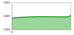
Open interactive mapOpen this POI on the interactive mapElevation profiledownloadTestroute Carina.gpx
iseltrail-etappe2-feldner-katarakte-c-ramona-walder.jpg © TVB Osttirol/Waldner Ramona Iseltrail Stage 2More InformationMore Information: Iseltrail Stage 2
Abstieg in Richtung Oberstalleralm © edifilm75 Herz-Ass VillgratentalDifficulty:mediumLength:75.6 kmDuration:34:00 hElevation uphill:5,703 mSee trailSee trail: Herz-Ass Villgratental
muhs-pyramide-panoramaweg-herbst23-c-anna-ladstaetter.jpeg © Anna Ladstätter Muhs panorama trailDifficulty:mediumLength:15.2 kmDuration:6:00 hElevation uphill:1,090 mSee trailSee trail: Muhs panorama trail
Europakreuz auf der Gr. Kinigat © A. Goller Carnic altitude trail. Stage 3: Obstansersee Hütte – PorzehütteDifficulty:mediumLength:11.3 kmDuration:6:00 hElevation uphill:650 mSee trailSee trail: Carnic altitude trail. Stage 3: Obstansersee Hütte – Porzehütte
lasoerling-hoehenweg-neue-reichenberger-huette-sonnenschein-2026-c-bernhard-assmair.jpeg © Bernhard Aßmair Lasörling altitude trailDifficulty:mediumLength:55.4 kmDuration:25:00 hElevation uphill:3,718 mSee trailSee trail: Lasörling altitude trail
loebbentoerl-schlatenkees-sommer-2024-c-bernhard-assmair.JPG © Bernhard Aßmair Venediger altitude trailDifficulty:difficultLength:55.5 kmDuration:27:00 hElevation uphill:3,975 mSee trailSee trail: Venediger altitude trail
wallfahrtskirche-maria-schnee-obermauern-nilbach-hoch-c-bernhard-assmair.jpg © Bernhard Aßmair Theme path "Virgen crossroads"Difficulty:easyLength:3.2 kmDuration:1:00 hElevation uphill:104 mSee trailSee trail: Theme path "Virgen crossroads"
Carnic altitude trail. Stage 4: Porzehütte – HochweißsteinhausMore InformationMore Information: Carnic altitude trail. Stage 4: Porzehütte – Hochweißsteinhaus
Sillianer Hütte © TVBOsttirol Carnic altitude trail. Stage 2: Sillianer Hütte- Obstansersee HütteDifficulty:mediumLength:8.7 kmElevation uphill:503 mSee trailSee trail: Carnic altitude trail. Stage 2: Sillianer Hütte- Obstansersee Hütte
Figerhorn - Goßglockner_TVB Osttirol_Elias Bachmann_Kals am Großglockner (1) © TVB Osttirol | Elias Bachmann FigerhornDifficulty:difficultLength:6.6 kmDuration:6:00 hElevation uphill:811 mSee trailSee trail: Figerhorn
Dolomitenrundfahrt Radrennen © Expa / Groder Around the Lienz DolomitesDifficulty:mediumLength:112.0 kmDuration:5:00 hElevation uphill:1,870 mGo to biketourGo to biketour: Around the Lienz Dolomites
Mountainbiken am Klammljoch © Erwin Haiden, bikeboard.at Klammljoch - Defereggental No. 102Difficulty:mediumLength:22.0 kmDuration:3:30 hElevation uphill:946 mGo to biketourGo to biketour: Klammljoch - Defereggental No. 102
Ortsansicht Anras © Rudolf Mascher Pustertal Alpine roadGo to attractionGo to attraction: Pustertal Alpine road
prosseggklamm-matrei-2024-c-peter-maier72_TVB Osttirol_Peter Maier_Matrei in Osttirol.jpg © Peter Maier Circular Hike Proßeggklamm - Hinteregg - Matrei i. O.Difficulty:mediumLength:12.4 kmDuration:5:20 hElevation uphill:722 mSee trailSee trail: Circular Hike Proßeggklamm - Hinteregg - Matrei i. O.
gloedis-gipfelkreuz-grossglockner-2026-c-bernhard-assmair.jpg © Bernhard Aßmair Glödis via ferrata routeOpening hours:openDifficulty:BExposition:SEDuration:1:00 hDuration:4:00 hElevation difference:230 mSee trailSee trail: Glödis via ferrata route
Filmoor-Standschützenhütte über das LeitertalDifficulty:mediumLength:8.5 kmDuration:5:30 hElevation uphill:900 mSee trailSee trail: Filmoor-Standschützenhütte über das Leitertal
Familienwanderung-Golzentipp-Kindermeile-TVB-Osttirol-c-Attic-FilmGmbH-Obertilliach.jpg © Attic Film GmbH Children's mile GolzentippDifficulty:easyLength:3.7 kmDuration:2:00 hElevation uphill:140 mSee trailSee trail: Children's mile Golzentipp
Naturbeobachtung mit dem Ranger © NPHT/Martin Lugger Hiking tour to Lucknerhütte 2.241mDifficulty:mediumLength:5.2 kmDuration:2:20 hElevation uphill:320 mSee trailSee trail: Hiking tour to Lucknerhütte 2.241m
Lienz, Peter Sagan Trail crop (1) © Tirol Werbung | Sebastian Schels Peter Sagan Trail No. 141Difficulty:mediumLength:5.0 kmDuration:0:30 hElevation uphill:90 mGo to biketourGo to biketour: Peter Sagan Trail No. 141
Mountainbiker auf Singletrail Kals © Miriam Raneburger Gornerwald Trail No. 139Difficulty:difficultLength:2.3 kmDuration:0:30 hGo to biketourGo to biketour: Gornerwald Trail No. 139
High and sacred – Stage 01 from Lavant to St. KorbinianMore InformationMore Information: High and sacred – Stage 01 from Lavant to St. Korbinian
hochundheilig-etappe4-hollbruck-c-peter-maier.jpg © Peter Maier High and sacred – Stage 04 from St. Oswald to InnichenMore InformationMore Information: High and sacred – Stage 04 from St. Oswald to Innichen
High and sacred – Stage 07 from St. Jakob im Defereggental to ObermauernMore InformationMore Information: High and sacred – Stage 07 from St. Jakob im Defereggental to Obermauern
Give feedback for a chance to win a special holiday experience!Click here for the surveyClick here for the survey