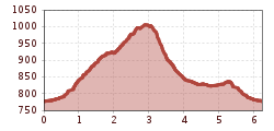
Mountain hikes "9 Treasures" Ebele

Oetz / Stubaier Alpen
Difficulty ratings: medium
Route length: 6.2 km
Duration: 2:30 h

OETZ -> Kalvarienberg -> Ebele -> Habichen -> OETZ

Tour information

  • Requirement: medium
  • Length: 6.2 km
  • Duration: 2:30 h
  • Elevation uphill:249 hm
  • Elevation downhill:249 hm
Highest point1,025 m

Starting point

Oetz central parking lot

Finishing point

Oetz central parking lot
  • Fitness level 3 / 6

Best time of year

  • January
  • February
  • March
  • April
  • May
  • June
  • July
  • August
  • September
  • October
  • November
  • December

Equipment

Intermediate mountain trail; suitable for sure-footed and experienced mountain hikers; good physical condition, mountain experience, and mountain equipment (see under Equipment) are necessary. Please check the current weather report at: www.oetztal.com/de/sommer.html Appropriate equipment such as breathable and weather-appropriate outdoor clothing, ankle-high hiking boots, wind, rain, and sun protection, hat, and possibly gloves is required for all hikes and tours. Carrying a first aid kit, a mobile phone, and possibly a hiking map, as well as enough provisions for hikes without catering options, is necessary.
Source: Ötztal

Description

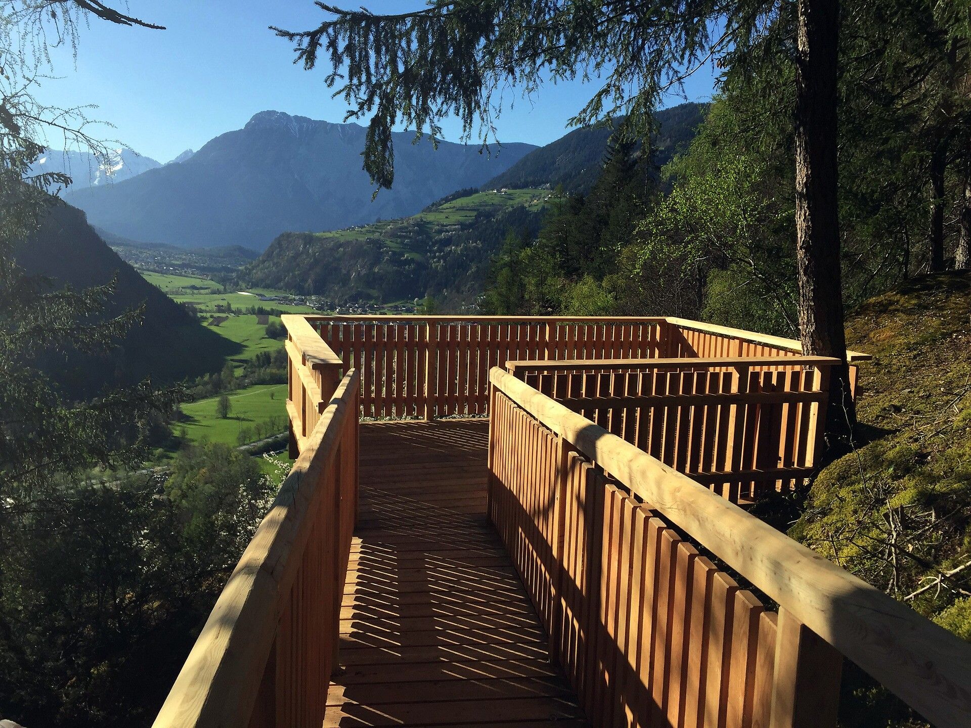
The starting point is the central parking lot in Oetz. First, you walk to the edge of the village to the adventure pool. On the wide forest path, you hike up to the chapel, after 3 more hairpin bends the path to the “Upper Ebele” viewpoint branches off to the right. At the platform, there is a magnificent view over the hamlet of Habichen. Afterwards, the hike leads more steeply down to the “Lower Ebele”, where the view stretches down the valley all the way to Sautens. Below the platform, you reach a forest path to Habichen. First, you walk next to the main road about 300 m to the beginning of the hamlet, then the path leads right past the houses until it again turns right onto a meadow path.

The “9 Treasures” are very special places. They invite visitors to linger. Take a short break to reflect on your thoughts and dreams. At each platform, you will find a “Treasures Book”. This serves to record these thoughts. Thus, each place becomes your special treasure!


Getting here

  • Arrival by public transport

    Travel comfortably and safely by train to Ötztal train station. The final stop or exit point is ÖTZTAL station. Afterwards, you can travel conveniently and quickly through the entire valley to your desired destination using public bus services or local taxi companies! The current bus schedule is available at: http://fahrplan.vvt.at

  • Parking

    The following parking options are available:

    • Central parking lot Oetz (paid)
    • Parking lot at the rafting entry point (at the end of Oetz on the right side) (paid)
    • Overnight parking during multi-day tours: Central parking lot Oetz, tickets are available at the Oetz information office.
    • Parking lot Acherkogelbahn (paid)

More tours in the surrounding area

  • Ötztal Trek Stage 4

    Difficulty: difficult
    Length: 8.9 km Duration: 4:00 h Elevation uphill: 802 m
  • Ötztal Trek Stage 3

    Difficulty: difficult
    Length: 10.4 km Duration: 4:00 h Elevation uphill: 842 m
  • Ötztal Trek Stage 10

    Difficulty: difficult
    Length: 11.1 km Duration: 4:30 h Elevation uphill: 1,476 m
  • Ötztal Trek Stage 8

    Difficulty: difficult
    Length: 9.3 km Duration: 3:30 h Elevation uphill: 274 m
  • Ötztal Trek

    Length: 246.4 km Duration: 84:25 h Elevation uphill: 18,910 m
  • Ötztal Trek Stage 20

    Opening hours: closed
    Difficulty: medium
    Length: 6.4 km Duration: 3:00 h Elevation uphill: 610 m
  • Ötztal Trek Stage 11

    Difficulty: difficult
    Length: 12.0 km Duration: 5:00 h Elevation uphill: 705 m
  • Ötztal Trek Stage 5

    Difficulty: difficult
    Length: 8.1 km Duration: 3:30 h Elevation uphill: 1,125 m
  • Ötztaler Urweg

    Length: 189.1 km Duration: 72:19 h Elevation uphill: 9,428 m
  • Ötztal Trek Stage 7

    Difficulty: difficult
    Length: 5.3 km Duration: 2:00 h Elevation uphill: 376 m
  • Ötztal Trek Stage 1

    Difficulty: medium
    Length: 18.6 km Duration: 6:30 h Elevation uphill: 1,561 m
  • Ötztal Trek Stage 14

    Difficulty: difficult
    Length: 6.3 km Duration: 3:00 h Elevation uphill: 1,004 m
  • Ötztal Trek Stage 12

    Difficulty: difficult
    Length: 4.8 km Duration: 2:00 h Elevation uphill: 592 m
  • Ötztal Trek Stage 22

    Difficulty: difficult
    Length: 21.5 km Duration: 8:00 h Elevation uphill: 647 m
  • Ötztal Trek Stage 21

    Difficulty: difficult
    Length: 9.4 km Duration: 4:30 h Elevation uphill: 1,270 m
  • Ötztal Trek Stage 6

    Difficulty: difficult
    Length: 7.6 km Duration: 3:30 h Elevation uphill: 640 m
  • Ötztal Trek Stage 17

    Difficulty: difficult
    Length: 16.4 km Duration: 6:00 h Elevation uphill: 1,080 m
  • Ötztal Trek Stage 16

    Difficulty: difficult
    Length: 6.9 km Duration: 2:30 h Elevation uphill: 358 m
  • Vent - Breslauer Hütte - Vernagthütte

    Difficulty: medium
    Length: 10.4 km Duration: 4:00 h Elevation uphill: 1,203 m
  • Mountain peak Rosskopf

    Difficulty: medium
    Length: 2.0 km Duration: 2:00 h Elevation uphill: 379 m
Newsletter

The mountain is calling? So does our newsletter!

In our monthly newsletter we reveal the best holiday tips for Tyrol.