Mountain hikes Hexenkopf (3.035 m)

closed
Serfaus / Samnaungruppe
Difficulty ratings: difficult
Route length: 7.7 km
Duration: 4:30 h

High alpine mountain tour with medium difficult climbing segments.

Tour information

  • Requirement: difficult
  • Length: 7.7 km
  • Duration: 4:30 h
  • Elevation uphill:840 hm
  • Elevation downhill:14 hm
Highest point2,987 m

Starting point

Lazid top station

Finishing point

Hexenkopf
Source: Serfaus-Fiss-Ladis

Description

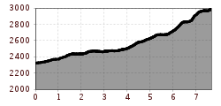
From the Lazidbahn top station (S301) over the Böderköpfe or on the vehicle track to the Scheid (S217). Just behind the Scheid at the signpost (S219) turn onto trail 26. Stay on the right side of the mountain,
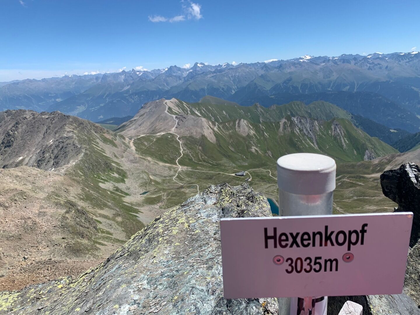
ascending slightly over some scree fields to the Arrezjoch (S228). From the Arrezjoch on the vehicle track to the Arrezjochbahn top station and further on trail no. 26 you reach the Masnerjoch (S239) in 1/2 hour. First go westwards over boulders, later on northwestwards to the Ostgrat (east ridge) and on to the first summit. First traverse this (for experienced hikers only) and later cross a gully going northwards, descend somewhat to the saddle point between the first and the main summit. From here, steeply upwards to the summit cross (S242). Variant: Starting point Hexenseehütte – Hexensattel (S235) – south ridge Hexenkopf (medium difficult climbing).

Nearby huts and mountain restaurants

More tours in the surrounding area

  • Wild Animals Trail

    Opening hours:closed
    Difficulty:easy
  • Marmot Trail

    Opening hours:closed
    Difficulty:easy
    Length:573 mDuration:0:20 hElevation uphill:12 m
  • Fiss to the Oberen Sattelkopf

    Opening hours:closed
    Difficulty:medium
    Length:5.6 kmDuration:3:00 hElevation uphill:1,079 m
  • Forscherpfad

    Opening hours:closed
    Difficulty:easy
    Length:3.4 kmDuration:1:30 hElevation uphill:219 m
  • Six Senses trail

    Opening hours:open
    Difficulty:easy
    Length:5.7 kmDuration:4:00 h
  • Six Senses trail

    Opening hours:closed
    Difficulty:easy
    Length:6.5 kmDuration:4:00 hElevation uphill:99 m
  • Murmeltiersteig (Marmot alpine trail)

    Opening hours:closed
    Difficulty:medium
    Length:6.9 kmDuration:3:00 hElevation uphill:302 m
Newsletter

The mountain is calling? So does our newsletter!

In our monthly newsletter we reveal the best holiday tips for Tyrol.