Mountain hikes Klein Horlachalm - Niederthai

Umhausen / Stubaier Alpen
Difficulty ratings: easy
Route length: 5.1 km
Duration: 1:40 h

NIEDERTHAI SENNHOF PARKING LOT -> Larstigalm -> KLEIN HORLACHALM  

Tour information

  • Requirement: easy
  • Length: 5.1 km
  • Duration: 1:40 h
  • Elevation uphill:376 hm
  • Elevation downhill:1 hm
Highest point1,916 m

Starting point

Sennhof parking lot

Finishing point

Klein Horlachalm
  • Fitness level 2 / 6

Best time of year

  • January
  • February
  • March
  • April
  • May
  • June
  • July
  • August
  • September
  • October
  • November
  • December

Equipment

Easy hiking trail; suitable for beginners and walkers

Please observe the current weather report

Appropriate equipment such as breathable and weather-appropriate outdoor clothing, ankle-high hiking boots, wind, rain and sun protection, hat, possibly gloves, is required for all hikes and routes. Bringing a first aid kit, a mobile phone, and possibly a hiking map, as well as enough provisions for hikes without options to stop for food, is necessary.

Source: Ötztal

Description

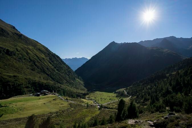
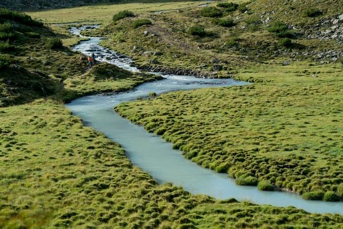
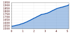
The hike begins in Niederthai at the Sennhof parking lot (next to the information center). From there, you follow the gently ascending forest road along the Horlachbach stream into the Horlach valley. After about an hour, you reach the Larstigalm and walk comfortably past it. The path briefly goes steeper uphill and then continues flat to a bridge. Crossing the wooden bridge on the left, you follow the wide hiking trail directly to the Klein Horlachalm. The easy hiking route is also very suitable for families and strollers/buggies. For the return, you can take the same route or alternatively, from Larstigalm, one of the two high-altitude trails Grastal or Bergmahderweg, which are however "not" suitable for strollers.


Nearby huts and mountain restaurants

Getting here

  • Arrival by public transport

    Travel comfortably and safely by train to the Ötztal train station. The final stop or exit point is the ÖTZTAL train station. Afterwards, you travel conveniently and quickly through the entire valley to your desired destination by public bus or local taxi companies! The current bus schedule is available at: http://fahrplan.vvt.at

  • Parking

    In Niederthai, the following parking options are available:

    • Sennhof parking lot | Cost: € 6.00 per car day ticket, compulsory from 7:00 am - 6:30 pm, multi-day tickets possible | Guests with disabilities - display valid ID - park for free | Buses park for free

More tours in the surrounding area

  • Ötztal Trek Stage 6

    Difficulty: difficult
    Length: 7.6 km Duration: 3:30 h Elevation uphill: 640 m
  • Ötztal Trek Stage 7

    Difficulty: difficult
    Length: 5.3 km Duration: 2:00 h Elevation uphill: 376 m
  • Ötztal Trek

    Length: 246.4 km Duration: 84:25 h Elevation uphill: 18,910 m
  • Ötztal Trek Stage 17

    Difficulty: difficult
    Length: 16.4 km Duration: 6:00 h Elevation uphill: 1,080 m
  • Ötztal Trek Stage 16

    Difficulty: difficult
    Length: 6.9 km Duration: 2:30 h Elevation uphill: 358 m
  • Winter hiking trail Rotes Wandl - No. 431

    Opening hours: closed
    Difficulty: easy
    Length: 1.5 km Duration: 0:45 h Elevation uphill: 52 m
  • Ötztal Trek Stage 21

    Difficulty: difficult
    Length: 9.4 km Duration: 4:30 h Elevation uphill: 1,270 m
  • Ötztal Trek Stage 4

    Difficulty: difficult
    Length: 8.9 km Duration: 4:00 h Elevation uphill: 802 m
  • Ötztal Trek Stage 3

    Difficulty: difficult
    Length: 10.4 km Duration: 4:00 h Elevation uphill: 842 m
  • Ötztal Trek Stage 10

    Difficulty: difficult
    Length: 11.1 km Duration: 4:30 h Elevation uphill: 1,476 m
  • Ötztal Trek Stage 8

    Difficulty: difficult
    Length: 9.3 km Duration: 3:30 h Elevation uphill: 274 m
  • Ötztal Trek Stage 20

    Opening hours: closed
    Difficulty: medium
    Length: 6.4 km Duration: 3:00 h Elevation uphill: 610 m
  • Ötztal Trek Stage 11

    Difficulty: difficult
    Length: 12.0 km Duration: 5:00 h Elevation uphill: 705 m
  • Ötztal Trek Stage 5

    Difficulty: difficult
    Length: 8.1 km Duration: 3:30 h Elevation uphill: 1,125 m
  • Ötztal Trek Stage 1

    Difficulty: medium
    Length: 18.6 km Duration: 6:30 h Elevation uphill: 1,561 m
  • Ötztal Trek Stage 14

    Difficulty: difficult
    Length: 6.3 km Duration: 3:00 h Elevation uphill: 1,004 m
  • Ötztal Trek Stage 12

    Difficulty: difficult
    Length: 4.8 km Duration: 2:00 h Elevation uphill: 592 m
  • Ötztaler Urweg

    Length: 189.1 km Duration: 72:19 h Elevation uphill: 9,428 m
  • Ötztal Trek Stage 22

    Difficulty: difficult
    Length: 21.5 km Duration: 8:00 h Elevation uphill: 647 m
  • Vent - Breslauer Hütte - Vernagthütte

    Difficulty: medium
    Length: 10.4 km Duration: 4:00 h Elevation uphill: 1,203 m
Newsletter

The mountain is calling? So does our newsletter!

In our monthly newsletter we reveal the best holiday tips for Tyrol.