Open interactive mapOpen this POI on the interactive mapElevation profileDownloadStubaier Gletscher - Hildesheimer Hütte.gpx
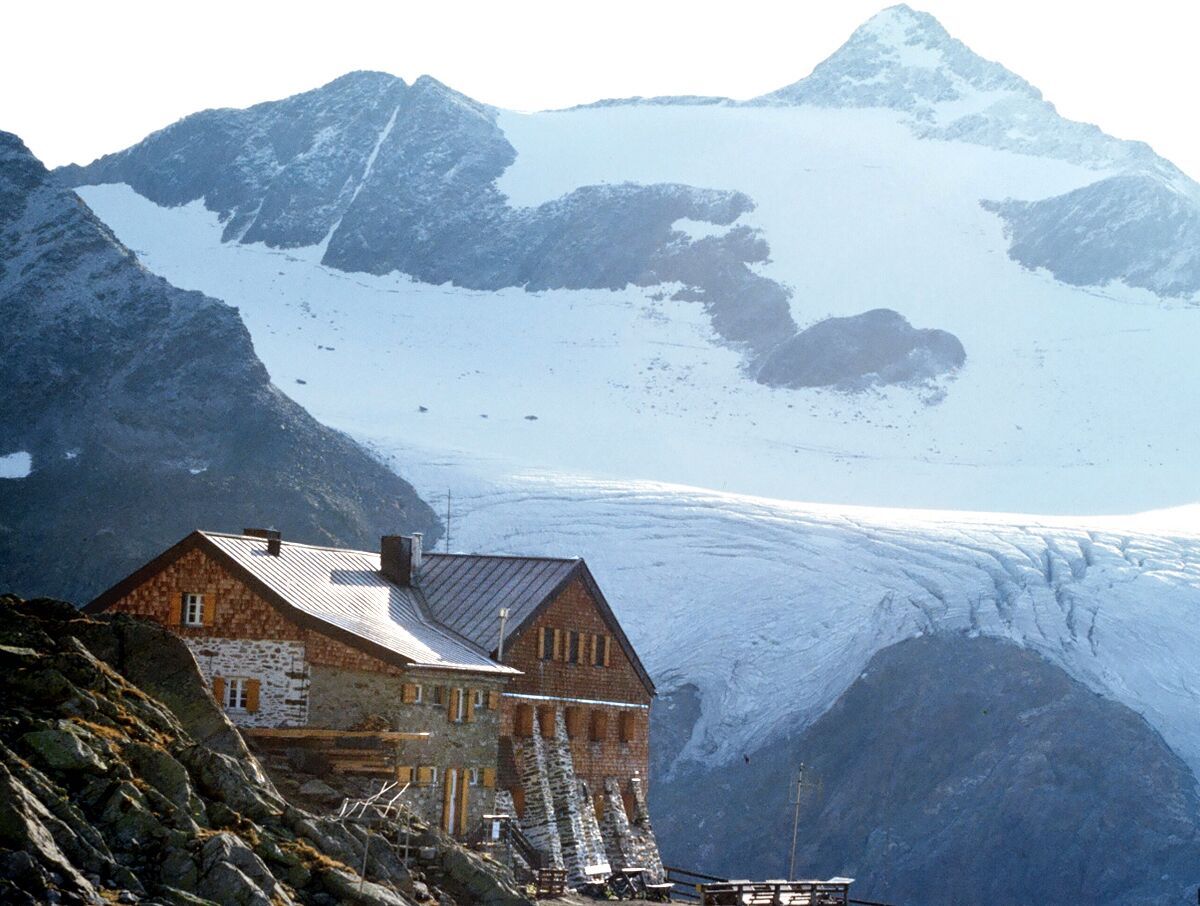
DescriptionFrom the Jochdohle glacier restaurant you can reach the Hildesheimer Hütte in about an hour's walk.
Hildesheimer Hütte 2.900m © Hildesheimer Hütte Hildesheimer Hütte 2.900mOpening hours:Open todayPlace:Neustift:Alpine pasture / hut / mountain restaurantsee restaurant detailssee restaurant details: Hildesheimer Hütte 2.900m
Faltegartenköpfl peakDifficulty:mediumLength:8.5 kmDuration:4:30 hElevation uphill:509 mSee trailSee trail: Faltegartenköpfl peak
The Sellrain Valley Mountain Hut Tour: stage 6Difficulty:difficultLength:9.4 kmDuration:4:00 hElevation uphill:730 mSee trailSee trail: The Sellrain Valley Mountain Hut Tour: stage 6
The Sellrain Valley Mountain Hut Tour: stage 5Difficulty:difficultLength:12.3 kmDuration:9:00 hElevation uphill:1,357 mSee trailSee trail: The Sellrain Valley Mountain Hut Tour: stage 5
Kristallwasser © Ötztal Tourismus Büro Oetz WIDI Theme Trail - Glück auf! Die spannende Welt der BergmännerDifficulty:easyLength:2.7 kmDuration:1:15 hElevation uphill:110 mSee trailSee trail: WIDI Theme Trail - Glück auf! Die spannende Welt der Bergmänner
Ramolhaus © Roland Grüner Ramolhaus - ObergurglDifficulty:difficultLength:7.8 kmDuration:4:00 hElevation uphill:1,095 mSee trailSee trail: Ramolhaus - Obergurgl
wilder mann_img_25851185 © Katharina Schatz Wilder MannDifficulty:mediumLength:7.0 kmDuration:2:30 hElevation uphill:665 mSee trailSee trail: Wilder Mann
Schneeschuhwanderung © Bernd Ritschel Circular hiking trail Horlachtal - NiederthaiOpening hours:closedDifficulty:easyLength:6.9 kmDuration:2:00 hElevation uphill:233 mGo to winter hikeGo to winter hike: Circular hiking trail Horlachtal - Niederthai
Hildesheimer Hütte © Katharina Schatz Ötztal Trek Stage 7Difficulty:difficultLength:5.3 kmDuration:2:00 hElevation uphill:376 mSee trailSee trail: Ötztal Trek Stage 7
Brandsee © Katharina Schatz Ötztal Trek Stage 1Difficulty:mediumLength:18.6 kmDuration:6:30 hElevation uphill:1,561 mSee trailSee trail: Ötztal Trek Stage 1
Hochjoch Hospiz © Roland Grüner Ötztal Trek Stage 14Difficulty:difficultLength:6.3 kmDuration:3:00 hElevation uphill:1,004 mSee trailSee trail: Ötztal Trek Stage 14
Martin-Busch-Hütte © Roland Grüner Ötztal Trek Stage 12Difficulty:difficultLength:4.8 kmDuration:2:00 hElevation uphill:592 mSee trailSee trail: Ötztal Trek Stage 12
winterwanderweg rotes wandl - nr. 431_img_56893137 © Ötztal Tourismus Büro Oetz Winter hiking trail Rotes Wandl - No. 431Opening hours:openDifficulty:easyLength:1.5 kmDuration:0:45 hElevation uphill:52 mGo to winter hikeGo to winter hike: Winter hiking trail Rotes Wandl - No. 431
Amberger Hütte © Roland Grüner Ötztal Trek Stage 4Difficulty:difficultLength:8.9 kmDuration:4:00 hElevation uphill:802 mSee trailSee trail: Ötztal Trek Stage 4
ötztal trek etappe 3_img_25877601 © Katharina Schatz Ötztal Trek Stage 3Difficulty:difficultLength:10.4 kmDuration:4:00 hElevation uphill:842 mSee trailSee trail: Ötztal Trek Stage 3
Obergurgl © Roland Grüner Ötztal Trek Stage 10Difficulty:difficultLength:11.1 kmDuration:4:30 hElevation uphill:1,476 mSee trailSee trail: Ötztal Trek Stage 10
Siegerlandhütte © Katharina Schatz Ötztal Trek Stage 8Difficulty:difficultLength:9.3 kmDuration:3:30 hElevation uphill:274 mSee trailSee trail: Ötztal Trek Stage 8
Amberger Hütte © Katharina Schatz Ötztal TrekLength:246.4 kmDuration:84:25 hElevation uphill:18,910 mSee trailSee trail: Ötztal Trek
Hauerseehütte © Katharina Schatz Ötztal Trek Stage 20Difficulty:mediumLength:6.4 kmDuration:3:00 hElevation uphill:610 mSee trailSee trail: Ötztal Trek Stage 20
Martin-Busch-Hütte © Roland Grüner Ötztal Trek Stage 11Difficulty:difficultLength:12.0 kmDuration:5:00 hElevation uphill:705 mSee trailSee trail: Ötztal Trek Stage 11
Amberger Hütte © Roland Grüner Ötztal Trek Stage 5Difficulty:difficultLength:8.1 kmDuration:3:30 hElevation uphill:1,125 mSee trailSee trail: Ötztal Trek Stage 5
Hildesheimer Hütte © Roland Grüner Ötztal Trek Stage 6Difficulty:difficultLength:7.6 kmDuration:3:30 hElevation uphill:640 mSee trailSee trail: Ötztal Trek Stage 6
Breslauer Hütte © Katharina Schatz Ötztal Trek Stage 17Difficulty:difficultLength:16.4 kmDuration:6:00 hElevation uphill:1,080 mSee trailSee trail: Ötztal Trek Stage 17
Vernagthütte © Katharina Schatz Ötztal Trek Stage 16Difficulty:difficultLength:6.9 kmDuration:2:30 hElevation uphill:358 mSee trailSee trail: Ötztal Trek Stage 16
vent - hochjoch hospiz - brandenburger haus_img_25921463 © Katharina Schatz Vent - Hochjoch Hospiz - Brandenburger HausDifficulty:difficultLength:14.7 kmDuration:6:00 hElevation uphill:1,573 mSee trailSee trail: Vent - Hochjoch Hospiz - Brandenburger Haus
Hängebrücke Längenfeld © Katharina Schatz Water Walk Brand-Burgstein LängenfeldDifficulty:mediumLength:6.7 kmDuration:2:30 hElevation uphill:396 mSee trailSee trail: Water Walk Brand-Burgstein Längenfeld
Give feedback for a chance to win a special holiday experience!Click here for the surveyClick here for the survey