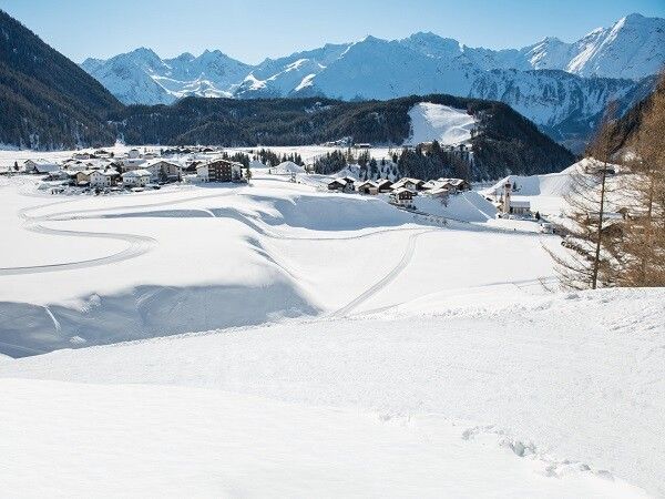
Winter hike Wiesle - Niederthai 326

open
Umhausen / Stubaier Alpen
Difficulty ratings: easy
Route length: 1.7 km
Duration: 1:00 h

PARKING LOT NORDIC SPORTS ARENA -> Wiesle snack station

Tour information

  • Requirement: easy
  • Length: 1.7 km
  • Duration: 1:00 h
  • Elevation uphill:107 hm
  • Elevation downhill:143 hm
Highest point1,637 m

Starting point

Parking lot Nordic Sports Arena

Finishing point

Wiesle
  • Fitness level 2 / 6
  • Technique 1 / 6

Best time of year

  • January
  • February
  • March
  • April
  • May
  • June
  • July
  • August
  • September
  • October
  • November
  • December

Equipment

Please note the current snow and avalanche report for the coming days: www.oetztal.com/en/ & https://lawinen.report/bulletin/latest

The Ötztal Tourism team will gladly inform you personally about the condition of the winter hiking trails.

Ötztal Tourism T +43 5 72 00 300 - info@laengenfeld.com

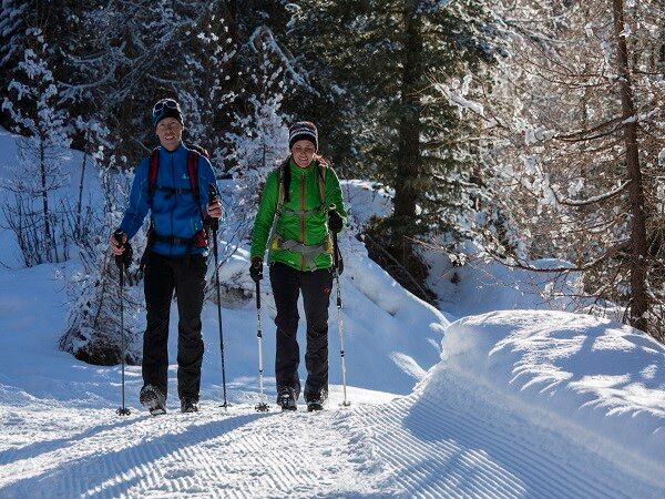
Appropriate equipment such as breathable and weather-appropriate outdoor clothing is required for all hikes and routes.

Source: Ötztal

Description

From the parking lot, walk a bit along the winter hiking trail towards the district of Tellerboden. After just 50 meters, turn left onto the signposted forest road "Wiesle" and follow it until you reach another intersection. At the intersection, turn left; the wide forest road/winter hiking trail continues to the Mauslasattel. From there, go straight for a bit and then downhill along the winter hiking trail to the Wiesle snack station.


Nearby huts and mountain restaurants

Getting here

  • Arrival by public transport

    Travel comfortably and safely by train to the Ötztal station. The final station or exit point is ÖTZTAL station. Afterwards, you can conveniently and quickly travel through the entire valley to your desired destination using the public transport or local taxi companies! The current bus timetable is available at: http://fahrplan.vvt.at

  • Parking

    Car Park Nordic Sports Arena

    The car park is subject to a charge from 07:00 to 22:00 and is open in summer and winter.

    • Tariffs: € 3.00 for 2 h, € 4.00 for 3 h, € 5.00 from 4 h
    • Possibility to pay cashless online with the PARKSTER APP.
    • The car park for people with handicap is free. Please deposit your handicap ID apparent in your car.

More tours in the surrounding area

  • Ötztal Trek Stage 6

    Difficulty: difficult
    Length: 7.6 km Duration: 3:30 h Elevation uphill: 640 m
  • Ötztal Trek Stage 7

    Difficulty: difficult
    Length: 5.3 km Duration: 2:00 h Elevation uphill: 376 m
  • Ötztal Trek

    Length: 246.4 km Duration: 84:25 h Elevation uphill: 18,910 m
  • Ötztal Trek Stage 17

    Difficulty: difficult
    Length: 16.4 km Duration: 6:00 h Elevation uphill: 1,080 m
  • Ötztal Trek Stage 16

    Difficulty: difficult
    Length: 6.9 km Duration: 2:30 h Elevation uphill: 358 m
  • Winter hiking trail Rotes Wandl - No. 431

    Opening hours: closed
    Difficulty: easy
    Length: 1.5 km Duration: 0:45 h Elevation uphill: 52 m
  • Ötztal Trek Stage 21

    Difficulty: difficult
    Length: 9.4 km Duration: 4:30 h Elevation uphill: 1,270 m
  • Ötztal Trek Stage 4

    Difficulty: difficult
    Length: 8.9 km Duration: 4:00 h Elevation uphill: 802 m
  • Ötztal Trek Stage 3

    Difficulty: difficult
    Length: 10.4 km Duration: 4:00 h Elevation uphill: 842 m
  • Ötztal Trek Stage 10

    Difficulty: difficult
    Length: 11.1 km Duration: 4:30 h Elevation uphill: 1,476 m
  • Ötztal Trek Stage 8

    Difficulty: difficult
    Length: 9.3 km Duration: 3:30 h Elevation uphill: 274 m
  • Ötztal Trek Stage 20

    Opening hours: closed
    Difficulty: medium
    Length: 6.4 km Duration: 3:00 h Elevation uphill: 610 m
  • Ötztal Trek Stage 11

    Difficulty: difficult
    Length: 12.0 km Duration: 5:00 h Elevation uphill: 705 m
  • Ötztal Trek Stage 5

    Difficulty: difficult
    Length: 8.1 km Duration: 3:30 h Elevation uphill: 1,125 m
  • Ötztal Trek Stage 1

    Difficulty: medium
    Length: 18.6 km Duration: 6:30 h Elevation uphill: 1,561 m
  • Ötztal Trek Stage 14

    Difficulty: difficult
    Length: 6.3 km Duration: 3:00 h Elevation uphill: 1,004 m
  • Ötztal Trek Stage 12

    Difficulty: difficult
    Length: 4.8 km Duration: 2:00 h Elevation uphill: 592 m
  • Ötztaler Urweg

    Length: 189.1 km Duration: 72:19 h Elevation uphill: 9,428 m
  • Ötztal Trek Stage 22

    Difficulty: difficult
    Length: 21.5 km Duration: 8:00 h Elevation uphill: 647 m
  • Vent - Breslauer Hütte - Vernagthütte

    Difficulty: medium
    Length: 10.4 km Duration: 4:00 h Elevation uphill: 1,203 m
Newsletter

The mountain is calling? So does our newsletter!

In our monthly newsletter we reveal the best holiday tips for Tyrol.