Description
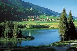
Reservoir with biotope and birds paradise that has been declared a nature reserve. A 2-km nature trail with information panels and a refuge passes around the reservoir.
Carnic altitude trail. Stage 2: Sillianer Hütte- Obstansersee HütteMore InformationMore about Carnic altitude trail. Stage 2: Sillianer Hütte- Obstansersee Hütte
Höfe Trail stage 3: Obertilliach - Wacht/UntertilliachMore InformationMore about Höfe Trail stage 3: Obertilliach - Wacht/Untertilliach
Höfe Trail stage 2: Kartitsch - ObertilliachMore InformationMore about Höfe Trail stage 2: Kartitsch - Obertilliach
Carnic altitude trail. Stage 4: Porzehütte – HochweißsteinhausMore InformationMore about Carnic altitude trail. Stage 4: Porzehütte – Hochweißsteinhaus
Höfe Trail stage 1: Sillian - KartitschMore InformationMore about Höfe Trail stage 1: Sillian - Kartitsch
High and sacred – Stage 04 from St. Oswald to InnichenMore InformationMore about High and sacred – Stage 04 from St. Oswald to Innichen
High and sacred – Stage 06 from Kalkstein to St. Jakob im DefereggentalMore InformationMore about High and sacred – Stage 06 from Kalkstein to St. Jakob im Defereggental
Golzentipp 2.317 mDifficulty: easy Length: 5.6 km Duration: 2:00 h Elevation uphill: 267 m See trailMore about Golzentipp 2.317 m
Toblacher PfannhornDifficulty: medium Length: 9.8 km Duration: 4:30 h Elevation uphill: 1,020 m See trailMore about Toblacher Pfannhorn
Große KinigatDifficulty: difficult Length: 8.5 km Elevation uphill: 1,250 m See trailMore about Große Kinigat
Filmoor-Standschützenhütte über das LeitertalDifficulty: medium Length: 8.5 km Duration: 5:30 h Elevation uphill: 900 m See trailMore about Filmoor-Standschützenhütte über das Leitertal
Herz-Ass VillgratentalDifficulty: medium Length: 76.0 km Duration: 34:00 h Elevation uphill: 5,750 m See trailMore about Herz-Ass Villgratental
Carnic altitude trail. Stage 3: Obstansersee Hütte – PorzehütteDifficulty: medium Length: 11.3 km Duration: 6:00 h Elevation uphill: 650 m See trailMore about Carnic altitude trail. Stage 3: Obstansersee Hütte – Porzehütte
The Höfe TrailDifficulty: easy Length: 50.6 km Duration: 10:15 h Elevation uphill: 1,882 m See trailMore about The Höfe Trail
Biathlon centre competition and training trail ObertilliachOpening hours: closed Difficulty: difficult Length: 4.2 km Elevation uphill: 100 m : Style: Skating, Classic Go to Cross-country skiing trailMore about Biathlon centre competition and training trail Obertilliach
Lake SchwarzseeDifficulty: medium Length: 7.8 km Duration: 3:30 h Elevation uphill: 790 m See trailMore about Lake Schwarzsee
Winter walking at the Dorfberg in East TirolOpening hours: closed Difficulty: difficult Length: 12.0 km Duration: 5:00 h Elevation uphill: 680 m Go to winter hikeMore about Winter walking at the Dorfberg in East Tirol
Rote Spitze 2,956 mDifficulty: medium Length: 10.2 km Duration: 5:30 h Elevation uphill: 1,260 m See trailMore about Rote Spitze 2,956 m
DorfbergDifficulty: medium Length: 17.6 km Duration: 5:30 h Elevation uphill: 770 m See trailMore about Dorfberg
OberstalleralmDifficulty: easy Length: 2.8 km Duration: 0:50 h Elevation uphill: 170 m See trailMore about Oberstalleralm
Obstansersee Hütte – PfannspitzeDifficulty: medium Length: 14.4 km Duration: 6:30 h Elevation uphill: 1,250 m See trailMore about Obstansersee Hütte – Pfannspitze
Volkzeiner HütteDifficulty: easy Length: 13.4 km Duration: 3:30 h Elevation uphill: 370 m See trailMore about Volkzeiner Hütte
Von Gandenwald/Kranzach zur WalderalmDifficulty: medium Length: 9.9 km Duration: 4:30 h Elevation uphill: 611 m See trailMore about Von Gandenwald/Kranzach zur Walderalm
Give feedback for a chance to win a special holiday experience!Click here for the surveyClick here for the survey