Mountain hikes Border area hiking trail

Kartitsch / Karnischer Hauptkamm
Difficulty ratings: medium
Route length: 15.9 km
Duration: 4:00 h

Derzeit wegen Holzarbeiten zwischen Biathlonzentrum und Schwalen bei Leiten gesperrt!
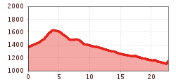
Tour information

  • Requirement: medium
  • Length: 15.9 km
  • Duration: 4:00 h
  • Elevation uphill:210 hm
  • Elevation downhill:480 hm
Highest point1,632 m

Starting point

Kartitsch

Finishing point

Untertilliach
  • Fitness level 3 / 6
  • Technique 3 / 6

Best time of year

  • January
  • February
  • March
  • April
  • May
  • June
  • July
  • August
  • September
  • October
  • November
  • December
Source: Hochpustertal

Description

On convenient forest trails and without using the busy roads, the ‘Grenzlandwanderweg’ brings together the three towns in Tirol‘s Gail-/Lesachtal - Kartitsch, Obertilliach and Untertilliach. The route proceeds to Erschbaumertal, Rauchenbach, Leiten, Mühlboden, proceeding south to Untertilliach. As an extension, the route may also be tackled from Heinfels/Rabland via Hollbruck, Kartitsch (proceed as above). Return journey possible on the bus.


Getting here

  • Arrival by public transport

    Mit dem Bus bis zur Haltestelle "Kartitsch Gemeindeamt"

  • Parking

    Parkplatz Sportzentrum Kartitsch

More tours in the surrounding area

Newsletter

The mountain is calling? So does our newsletter!

In our monthly newsletter we reveal the best holiday tips for Tyrol.