Mountain hikes Hauersee Hut 2383m - Längenfeld

Längenfeld / Ötztal Alps
Difficulty ratings: medium
Route length: 6.1 km
Duration: 3:49 h

PLEASE NOTE: Due to forestry work, the trail from the district of Lehn to the Stabele Alm is closed. Alternatively, you can reach the Stabele Alm via the forest road. LÄNGENFELD LEHN -> towards Stabelealm -> Innerbergalm -> HAUERSEE HUT

Tour information

  • Requirement: medium
  • Length: 6.1 km
  • Duration: 3:49 h
  • Elevation uphill:1,200 hm
  • Elevation downhill:14 hm
Highest point2,383 m

Starting point

Längenfeld/Lehn

Finishing point

Hauersee
  • Fitness level 4 / 6

Best time of year

  • January
  • February
  • March
  • April
  • May
  • June
  • July
  • August
  • September
  • October
  • November
  • December

Equipment

Appropriate equipment such as breathable and weather-appropriate outdoor clothing is required for all hikes and routes. Bringing a first aid kit, a mobile phone and possibly a hiking map, as well as sufficient provisions on hikes without refreshment options, is necessary.

Appropriate equipment such as breathable and weather-appropriate outdoor clothing,

ankle-high hiking boots, wind, rain and sun protection, hat, possibly gloves, is required for all

hikes and routes. Bringing a first aid kit, a mobile phone and possibly

a hiking map, as well as enough provisions for hikes without refreshment options, is necessary

Source: TVB Ötztal Tourismus

Description

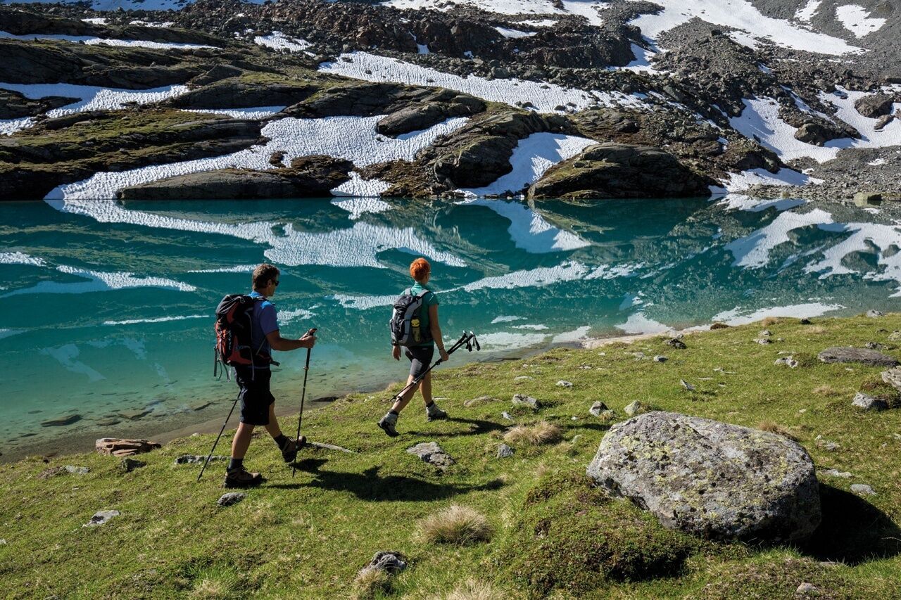
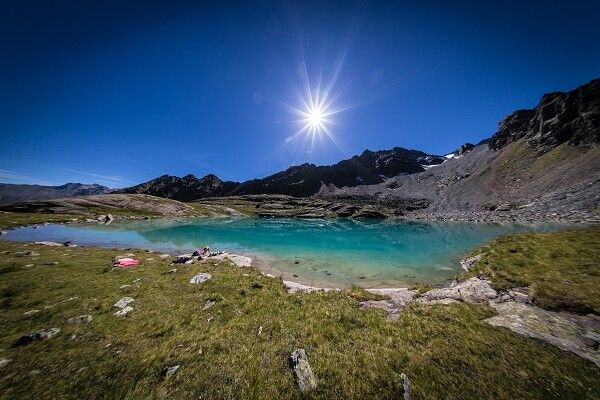
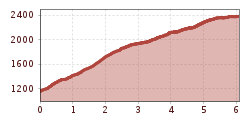
The start of this wonderful hike is in the Längenfeld district of Lehn. The ascent takes place via a trail that leads steadily uphill through dense forest. From time to time, you can catch a glimpse of the Lehner Waterfall. Except for a section of the path that goes over a well-secured stone slab, you walk on forest ground.  After about 2 hours of walking you reach the tree line and Stabelealm comes into view. You leave the turn-off to this hut on the right and continue walking through lush green meadows towards Innerbergalm. After a short break, you continue over the Hauer ridge towards Hauersee.  After some flatter and steeper sections in this cirque, you reach Hauersee which shimmers milky green to turquoise blue depending on the season. Surrounded by the so-called Fünffingerspitzen, you can enjoy once again the pleasant calm at 2300 meters altitude before you start the descent.


Nearby huts and mountain restaurants

Getting here

  • Arrival by public transport

    Public transport                                      

    Travel comfortably and safely by train. The final station or exit point is ÖTZTAL station. Afterwards, you travel conveniently and quickly with public bus lines or local taxi companies through the entire valley to your desired destination. The current bus timetable is available at: fahrplan.vvt.at

  • Parking

    The following parking options are available in Längenfeld:

    • directly at the starting point in Längenfeld/Lehn - subject to fees

More tours in the surrounding area

  • Ötztal Trek Stage 7

    Difficulty:difficult
    Length:5.3 kmDuration:2:00 hElevation uphill:376 m
  • Ötztal Trek

    Length:246.4 kmDuration:84:25 hElevation uphill:18,910 m
  • Ötztal Trek Stage 17

    Difficulty:difficult
    Length:16.4 kmDuration:6:00 hElevation uphill:1,080 m
  • Ötztal Trek Stage 6

    Difficulty:difficult
    Length:7.6 kmDuration:3:30 hElevation uphill:640 m
  • Ötztal Trek Stage 4

    Difficulty:difficult
    Length:8.9 kmDuration:4:00 hElevation uphill:802 m
  • Ötztal Trek Stage 10

    Difficulty:difficult
    Length:11.1 kmDuration:4:30 hElevation uphill:1,476 m
  • Ötztal Trek Stage 8

    Difficulty:difficult
    Length:9.3 kmDuration:3:30 hElevation uphill:274 m
  • Ötztal Trek Stage 1

    Difficulty:medium
    Length:18.6 kmDuration:6:30 hElevation uphill:1,561 m
  • Ötztal Trek Stage 16

    Difficulty:difficult
    Length:6.9 kmDuration:2:30 hElevation uphill:358 m
  • Ötztal Trek Stage 20

    Difficulty:medium
    Length:6.4 kmDuration:3:00 hElevation uphill:610 m
  • Ötztal Trek Stage 3

    Difficulty:difficult
    Length:10.4 kmDuration:4:00 hElevation uphill:842 m
  • Ötztal Trek Stage 14

    Difficulty:difficult
    Length:6.3 kmDuration:3:00 hElevation uphill:1,004 m
  • Ötztal Trek Stage 22

    Difficulty:difficult
    Length:21.5 kmDuration:8:00 hElevation uphill:647 m
  • Ötztal Trek Stage 21

    Difficulty:difficult
    Length:9.4 kmDuration:4:30 hElevation uphill:1,270 m
  • Ötztal Trek Stage 11

    Difficulty:difficult
    Length:12.0 kmDuration:5:00 hElevation uphill:705 m
  • Ötztal Trek Stage 5

    Difficulty:difficult
    Length:8.1 kmDuration:3:30 hElevation uphill:1,125 m
  • Ötztaler Urweg

    Length:189.1 kmDuration:72:19 hElevation uphill:9,428 m
  • Ötztal Trek Stage 12

    Difficulty:difficult
    Length:4.8 kmDuration:2:00 hElevation uphill:592 m
  • Stuibenfall hike - Umhausen

    Opening hours:open
    Difficulty:easy
    Length:2.9 kmDuration:1:45 hElevation uphill:456 m
Newsletter

The mountain is calling? So does our newsletter!

In our monthly newsletter we reveal the best holiday tips for Tyrol.