Venediger Altitude Trail Stage 5

Virgen in Osttirol / Venedigergruppe
Difficulty ratings: difficult
Route length: 9.2 km
Duration: 5:00 h

For today's stage, it is important to clarify the current conditions: Depending on the snow conditions, this passage may not be accessible until midsummer. If the conditions are right, the stage will impress you with its many views of sometimes bizarre rock formations. The Badener Hütte offers views of the Glockner, Granatspitz and Schober groups as well as the icefall on the north side of the Kristallwand.

Tour character

Medium-difficulty tour on red mountain paths. Sure-footedness and alpine knowledge are essential for the route in high alpine terrain. A good level of fitness is required.

Tour information

  • Requirement: difficult
  • Length: 9.2 km
  • Duration: 5:00 h
  • Elevation uphill:550 hm
  • Elevation downhill:690 hm
Highest point2,871 m

Starting point

Bonn-Matreier Hütte 2.750m

Finishing point

Badener Hütte 2.608m
  • Fitness level 4 / 6
  • Technique 5 / 6

Features

  • Multi-day hike

Best time of year

  • January
  • February
  • March
  • April
  • May
  • June
  • July
  • August
  • September
  • October
  • November
  • December
Source: Nationalparkregion Hohe Tauern Osttirol

Description

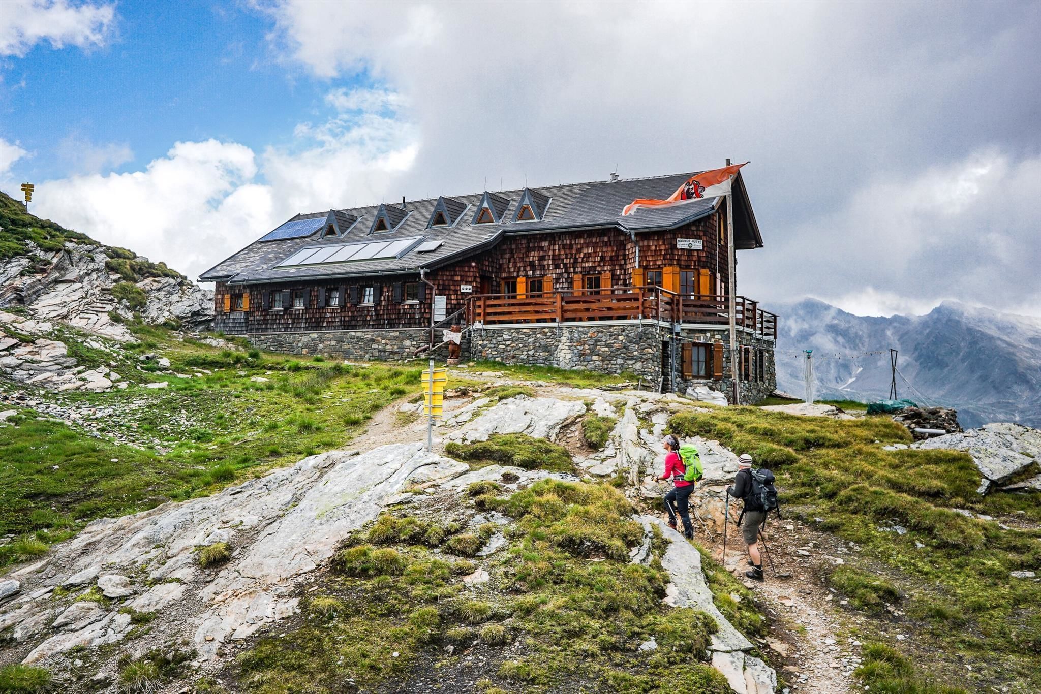
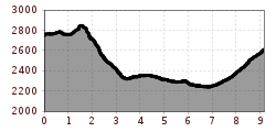
Via the Kälberscharte (2.791m) and the Galtenscharte (2,871 m) the route continues to the Badener Hütte. This section is, depending on snow conditions, often only accessible in high summer. A short section is also secured with a rope, but can be easily climbed without a via ferrata set. Due to the danger of falling rocks, however, this section should only be climbed in dry conditions. The rest of the route leads through the picturesque and rustic Frosnitztal valley to the Badenerhütte.

More tours in the surrounding area

  • Hike to the Venedigerhaus Innergschlöß

    Difficulty: easy
    Length: 8.5 km Duration: 2:30 h Elevation uphill: 180 m
  • Muhs panorama trail

    Difficulty: medium
    Length: 15.2 km Duration: 6:00 h Elevation uphill: 1,090 m
  • Hiking tour to Lasörlinghütte 2.350m

    Difficulty: medium
    Length: 14.6 km Duration: 7:10 h Elevation uphill: 1,080 m
  • Hike to Neuen Reichenberger Hütte

    Difficulty: medium
    Length: 9.1 km Duration: 9:00 h Elevation uphill: 1,210 m
  • Badener Hütte

    Difficulty: difficult
    Length: 23.2 km Duration: 11:30 h Elevation uphill: 1,750 m
  • Hike to Kalser Tauernhaus

    Difficulty: medium
    Length: 12.2 km Duration: 4:00 h Elevation uphill: 244 m
  • Hiking tour to Neue Sajathütte 2.600m

    Difficulty: medium
    Length: 10.3 km Duration: 6:50 h Elevation uphill: 1,080 m
  • Lucknerhaus - Stüdlhütte

    Difficulty: medium
    Length: 9.3 km Duration: 5:30 h Elevation uphill: 862 m
  • Lasörling altitude trail

    Difficulty: medium
    Length: 57.0 km Duration: 25:00 h Elevation uphill: 3,740 m
  • Figerhorn

    Difficulty: difficult
    Length: 6.5 km Duration: 6:00 h Elevation uphill: 807 m
  • Venediger altitude trail

    Difficulty: difficult
    Length: 55.5 km Duration: 27:00 h Elevation uphill: 3,915 m
  • Lasörling 3.098m

    Difficulty: difficult
    Length: 21.9 km Duration: 12:00 h Elevation uphill: 1,940 m
  • Rotenkogel

    Difficulty: difficult
    Length: 3.9 km Duration: 3:00 h Elevation uphill: 383 m
Newsletter

The mountain is calling? So does our newsletter!

In our monthly newsletter we reveal the best holiday tips for Tyrol.