Long-distance hike Adlerweg trail. Stage 1: Ströden – Johannishütte

Prägraten am Großvenediger / Venedigergruppe
Difficulty ratings: medium
Route length: 13.0 km
Duration: 7:00 h

Adlerweg trail. Stage 1: Ströden – Johannishütte

Tour information

  • Requirement: medium
  • Length: 13.0 km
  • Duration: 7:00 h
  • Elevation uphill:1,360 hm
  • Elevation downhill:654 hm
Highest point2,774 m

Starting point

Parkplatz Ströden

Finishing point

Johannishütte
  • Fitness level 3 / 6
  • Technique 3 / 6

Best time of year

  • January
  • February
  • March
  • April
  • May
  • June
  • July
  • August
  • September
  • October
  • November
  • December
Source: TVB Osttirol

Description

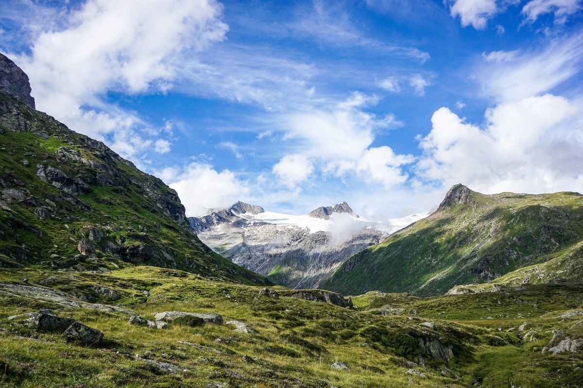
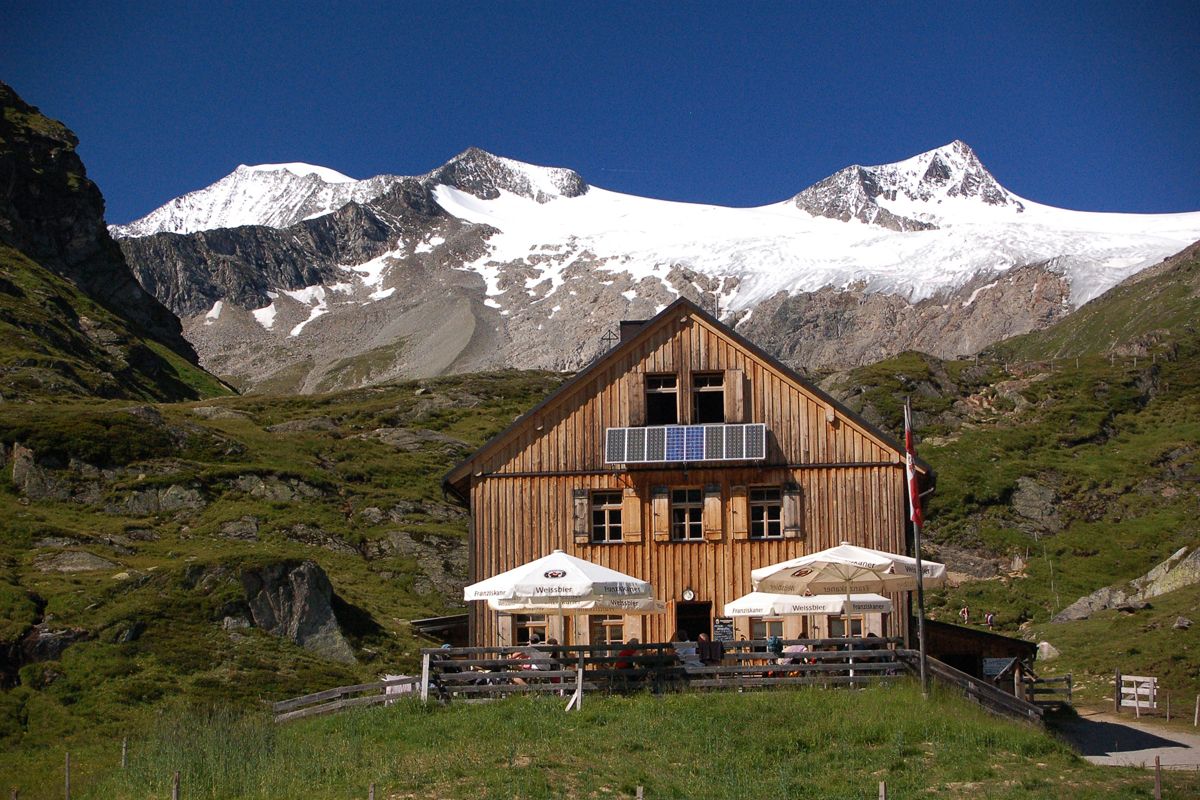
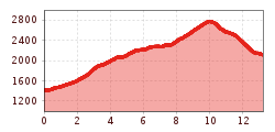
Starting point is the car park in Ströden, from there after the bridge proceed along the Maurerbach up to the Stoanalm snack station at 1450 metres. On the orographic left side of the river the trail heads to the valley station for the goods cable car. Continue on a steep trail up a valley section where larch trees are growing. After some two dozen steep hairpin bends up to Göriacher Ochsnerhütte (1948 metres), continue on the path, always close to the river, via tree-lined gentle slopes into the run-up to the glacier-covered Venediger mountains and to the bridge at the upper Ochsnerhütte at Maurerbach. The powerful glacier river separates the Göriacher from the Maurer Alpe in the west. The route now proceeds in the final slope up to the Essener-Rostocker Hütte, in a moraine area of the secluded Simonykees area. After a well-deserved break continue hiking from Essener-Rostocker Hütte via Schweriner Weg. Negotiate the mountain flank via the hairpin bends and after about an hour of walking proceed along the south west slope of the Kleinen Geiger. Proceed now via the grinding marks which were left during the Ice Age and via widely scattered scree fields to Türml and its bright red rocks, at whose base is the Türmljoch (2772 metres). To the east of here a path proceeds in loops along the path through snow hollows and the rubble surface, continuing down along the eastern slope of the Dorferkamm. Around ¼ hour later you turn, over a few rivulets, heading north east. The path then turns into terrain heading south across a mountain slope, down into the village of Bach, where you get to gaze in wonder at the lovely ground rocks. Finally the route proceeds past the memorial cross and via Zettalunitzbach on the final section to the traditional and spacious Johannishütte (2121 metres).

Please note: This is a very long day's stage - an early start is recommended!

Nearby huts and mountain restaurants

Getting here

  • Arrival by public transport

    Prägraten am Großvenediger - Hinterbichl/Ströden

  • Parking

    Parkplatz Ströden 

More tours in the surrounding area

  • Lasörling altitude trail

    Difficulty: medium
    Length: 57.0 km Duration: 25:00 h Elevation uphill: 3,740 m
  • Venediger altitude trail

    Difficulty: difficult
    Length: 55.5 km Duration: 27:00 h Elevation uphill: 3,915 m
  • Figerhorn

    Difficulty: difficult
    Length: 6.5 km Duration: 6:00 h Elevation uphill: 807 m
  • Hike to the Venedigerhaus Innergschlöß

    Difficulty: easy
    Length: 8.5 km Duration: 2:30 h Elevation uphill: 180 m
  • Rotenkogel

    Difficulty: difficult
    Length: 3.9 km Duration: 3:00 h Elevation uphill: 383 m
  • Lasörling 3.098m

    Difficulty: difficult
    Length: 21.9 km Duration: 12:00 h Elevation uphill: 1,940 m
  • Umbal waterfalls nature force trail

    Difficulty: easy
    Length: 5.8 km Duration: 2:30 h Elevation uphill: 250 m
  • Muhs panorama trail

    Difficulty: medium
    Length: 15.2 km Duration: 6:00 h Elevation uphill: 1,090 m
  • Hike to Neuen Reichenberger Hütte

    Difficulty: medium
    Length: 9.1 km Duration: 9:00 h Elevation uphill: 1,210 m
  • Hiking tour to Lasörlinghütte 2.350m

    Difficulty: medium
    Length: 14.6 km Duration: 7:10 h Elevation uphill: 1,080 m
  • Badener Hütte

    Difficulty: difficult
    Length: 23.2 km Duration: 11:30 h Elevation uphill: 1,750 m
  • Lucknerhaus - Stüdlhütte

    Difficulty: medium
    Length: 9.3 km Duration: 5:30 h Elevation uphill: 862 m
  • Hike to Kalser Tauernhaus

    Difficulty: medium
    Length: 12.2 km Duration: 4:00 h Elevation uphill: 244 m
  • Hiking tour to Neue Sajathütte 2.600m

    Difficulty: medium
    Length: 10.3 km Duration: 6:50 h Elevation uphill: 1,080 m
  • Böses Weibl

    Difficulty: difficult
    Length: 14.1 km Duration: 8:00 h Elevation uphill: 1,193 m
  • Eagle Walk Stage O1: Ströden - Johannis Hütte

    Difficulty: medium
    Length: 13.0 km Duration: 6:30 h Elevation uphill: 1,430 m
Newsletter

The mountain is calling? So does our newsletter!

In our monthly newsletter we reveal the best holiday tips for Tyrol.