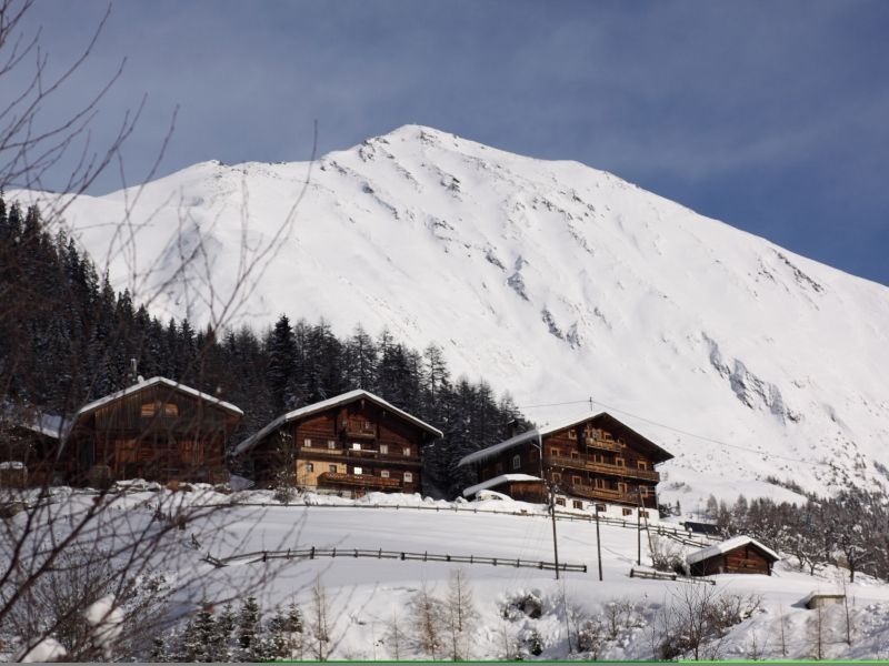
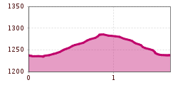
Open interactive mapOpen this POI on the interactive mapElevation profileLesachbach river bank trail.gpx
DescriptionAs a connecting section running between Kals/Lesach and Kals/Arnig along the Lesachbach from Knopfbrücke to Patnerbrücke in Unterlesach.
wanderung-grosser-zunig-wokenmeer-c-bernhard-assmair.jpg © Bernhard Aßmair Lasörling altitude trailDifficulty: medium Length: 57.0 km Duration: 25:00 h Elevation uphill: 3,740 m See trailSee trail: Lasörling altitude trail
wandern2-neuepragerhuette-c-dezordo-desiree.jpg © Desirèe De Zordo Venediger altitude trailDifficulty: difficult Length: 55.5 km Duration: 27:00 h Elevation uphill: 3,915 m See trailSee trail: Venediger altitude trail
Figerhorn - Goßglockner_TVB Osttirol_Elias Bachmann_Kals am Großglockner (1) © TVB Osttirol | Elias Bachmann FigerhornDifficulty: difficult Length: 6.5 km Duration: 6:00 h Elevation uphill: 807 m See trailSee trail: Figerhorn
wandern-wolken-sonnenaufgang-bergtour-lasoerling-2010-c-bernhard-assmair.jpg © Bernhard Aßmair Lasörling 3.098mDifficulty: difficult Length: 21.9 km Duration: 12:00 h Elevation uphill: 1,940 m See trailSee trail: Lasörling 3.098m
rotenkogel-sonnenaufgang-c-konrad-klaunzer.JPG © Konrad Klaunzer RotenkogelDifficulty: difficult Length: 3.9 km Duration: 3:00 h Elevation uphill: 383 m See trailSee trail: Rotenkogel
iseltrail-hangebruecke-mai-2024-c-peter-maier-183_TVB Osttirol_Peter Maier_Virgen in Osttirol.jpg © Peter Maier Circular hike suspension bridge Isel Canyon via "Hohe Bank"Opening hours: closed Difficulty: medium Length: 8.1 km Duration: 2:40 h Elevation uphill: 300 m See trailSee trail: Circular hike suspension bridge Isel Canyon via "Hohe Bank"
wanderung-umbalfaelle-wasserfall-c-bernhard-assmair.jpg © Bernhard Aßmair Umbal waterfalls nature force trailDifficulty: easy Length: 5.8 km Duration: 2:30 h Elevation uphill: 250 m See trailSee trail: Umbal waterfalls nature force trail
Glacier trail Innergschlöss/SchlatenkeesDifficulty: medium Length: 9.4 km Duration: 5:00 h Elevation uphill: 680 m See trailSee trail: Glacier trail Innergschlöss/Schlatenkees
muhs-pyramide-panoramaweg-herbst23-c-anna-ladstaetter.jpeg © Anna Ladstätter Muhs panorama trailDifficulty: medium Length: 15.2 km Duration: 6:00 h Elevation uphill: 1,090 m See trailSee trail: Muhs panorama trail
Gschlöss mit Venedigermassiv_TVB Osttirol_Kurzthaler Martin_Keine Ortsangabe.jpg © Kurzthaler Martin Hike to the Venedigerhaus InnergschlößDifficulty: easy Length: 8.5 km Duration: 2:30 h Elevation uphill: 180 m See trailSee trail: Hike to the Venedigerhaus Innergschlöß
wanderung-neue-sajathuette-ausblick-c-bernhard-assmair.jpg © Bernhard Aßmair Hiking tour to Neue Sajathütte 2.600mDifficulty: medium Length: 10.3 km Duration: 6:50 h Elevation uphill: 1,080 m See trailSee trail: Hiking tour to Neue Sajathütte 2.600m
aussergschloess_06-19_(c)www.bergpixel.de © Bergpixel Hike to the Berghaus AußergschlössDifficulty: easy Length: 5.2 km Duration: 1:45 h Elevation uphill: 170 m See trailSee trail: Hike to the Berghaus Außergschlöss
Stüdlhütte-Kals-Sommer2019-Matteo Bachmann.JPG © Matteo Bachmann Lucknerhaus - StüdlhütteDifficulty: medium Length: 9.3 km Duration: 5:30 h Elevation uphill: 862 m See trailSee trail: Lucknerhaus - Stüdlhütte
Neue Reichenbergerhütte_TVB Osttirol_Geyer Johannes_No location given © TVB Osttirol | Johannes Geyer Hike to Neuen Reichenberger HütteDifficulty: medium Length: 9.1 km Duration: 9:00 h Elevation uphill: 1,210 m See trailSee trail: Hike to Neuen Reichenberger Hütte
Kalser Tauernhaus im Nationalpark Hohe Tauern © NPHT Hannah Assil und Michael Kastl Hike to Kalser TauernhausDifficulty: medium Length: 12.2 km Duration: 4:00 h Elevation uphill: 244 m See trailSee trail: Hike to Kalser Tauernhaus
Bergabbau vor vielen Jahren am Gassla Anda Weg.jpg © Klaunzer Badener HütteDifficulty: difficult Length: 23.2 km Duration: 11:30 h Elevation uphill: 1,750 m See trailSee trail: Badener Hütte
Hoch und Heilig Etappe 7 Virgen Lasörlinghütte_TVB Osttirol_Peter Maier_Virgen in Osttirol.jpg © Peter Maier Hiking tour to Lasörlinghütte 2.350mDifficulty: medium Length: 14.6 km Duration: 7:10 h Elevation uphill: 1,080 m See trailSee trail: Hiking tour to Lasörlinghütte 2.350m
wandern-sudetendeutschehuette2-c-desiree-dezordo.jpg © Desirèe De Zordo Hiking tour to Sudetendeutschen Hütte 2.650mDifficulty: medium Length: 15.5 km Duration: 7:00 h Elevation uphill: 1,200 m See trailSee trail: Hiking tour to Sudetendeutschen Hütte 2.650m
Böses WeiblDifficulty: difficult Length: 14.1 km Duration: 8:00 h Elevation uphill: 1,193 m See trailSee trail: Böses Weibl
Adlerweg Osttirol Etappe 2 © Tirol Werbung/Familie Kratzer Eagle Walk Stage O2: Johannishütte - EisseehütteDifficulty: difficult Length: 10.0 km Duration: 6:00 h Elevation uphill: 1,020 m See trailSee trail: Eagle Walk Stage O2: Johannishütte - Eisseehütte
Adlerweg Osttirol Etappe 3: Bonn-Matreier-Hütte © Tirol Werbung/Raimund Mühlburger Eagle Walk Stage O3: Eisseehütte - Bonn-Matreier-HütteDifficulty: medium Length: 7.0 km Duration: 3:30 h Elevation uphill: 600 m See trailSee trail: Eagle Walk Stage O3: Eisseehütte - Bonn-Matreier-Hütte
Adlerweg-Etappe O6: Sudetendeutsche Hütte © DAV Eagle Walk Stage O7: Sudetendeutsche Hütte - Kalser TauernhausDifficulty: medium Length: 7.5 km Duration: 4:00 h Elevation uphill: 300 m See trailSee trail: Eagle Walk Stage O7: Sudetendeutsche Hütte - Kalser Tauernhaus
Adlerweg Osttirol Etappe 1 © Tirol Werbung/Frank Bauer Eagle Walk Stage O1: Ströden - Johannis HütteDifficulty: medium Length: 13.0 km Duration: 6:30 h Elevation uphill: 1,430 m See trailSee trail: Eagle Walk Stage O1: Ströden - Johannis Hütte
Adlerweg-Etappe O5: Badener Hütte © Badener Hütte Eagle Walk Stage O4: Bonn-Matreier Hütte - Badener HütteDifficulty: difficult Length: 10.0 km Duration: 5:00 h Elevation uphill: 800 m See trailSee trail: Eagle Walk Stage O4: Bonn-Matreier Hütte - Badener Hütte
Adlerweg-Etappe O6: Sudetendeutsche Hütte © DAV Eagle Walk Stage O6: Matrei in Osttirol - Sudetendeutsche HütteDifficulty: medium Length: 8.0 km Duration: 4:00 h Elevation uphill: 1,250 m See trailSee trail: Eagle Walk Stage O6: Matrei in Osttirol - Sudetendeutsche Hütte
Give feedback for a chance to win a special holiday experience!Click here for the surveyClick here for the survey


")


")


www.bergpixel.de")


