Hut hike Hike Hochkreuz 2.739m

St. Jakob im Defereggental / Villgraten Mountains
Difficulty ratings: difficult
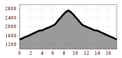
Route length: 17.5 km
Duration: 6:30 h

Escape from the daily grind and into the heart of adventure – your route into nature
Tour information

  • Requirement: difficult
  • Length: 17.5 km
  • Duration: 6:30 h
  • Elevation uphill:1,300 hm
  • Elevation downhill:1,300 hm
Highest point2,739 m

Starting point

Kapelle Maria Hilf

Finishing point

Hochkreuz
  • Fitness level 4 / 6
  • Technique 3 / 6

Best time of year

  • January
  • February
  • March
  • April
  • May
  • June
  • July
  • August
  • September
  • October
  • November
  • December
Source: TVB Osttirol

Description

The starting point for this tour is Maria Hilf. From here proceed to Alpe Stalle and continue via the trail down into the valley to Hintere Stalle, where the trail ends. From here via a steep path, ascending slightly to the head of the valley. Then the right side of the slope proceeds via hilly Alpine meadows up to a small altitude plateau on the Pfoisattel, then bears right up to the highest point.

Nearby huts and mountain restaurants

  • Alpe Stalle 1.714m

    Opening hours:Open today
    Place:St. Jakob i. D.
    :Alpine pasture / hut / mountain restaurant

Getting here

  • Arrival by public transport

    Bushaltestelle St. Jakob i. D. Mariahilf Dorf

  • Parking

    Beim kleinen Kirchlein in Maria Hilf

Weather

Today

light rain showers
18°C/11°C
65%6.5l5 km/h

Wed

mainly clear
21°C/10°C
50%1l5 km/h

Thu

mainly clear
24°C/12°C
30%0.2l5 km/h
Go to weather forecast

More tours in the surrounding area

Newsletter

The mountain is calling? So does our newsletter!

In our monthly newsletter we reveal the best holiday tips for Tyrol.