Mountain hikes Kircher Alm

Untertilliach / Gailtaler Alpen
Difficulty ratings: easy
Route length: 11.5 km
Duration: 4:00 h

Kircher Alm

Tour information

  • Requirement: easy
  • Length: 11.5 km
  • Duration: 4:00 h
  • Elevation uphill:830 hm
  • Elevation downhill:590 hm
Highest point2,040 m

Starting point

Untertilliach

Finishing point

Untertilliach
  • Fitness level 3 / 6
  • Technique 2 / 6

Features

  • Circular route

Best time of year

  • January
  • February
  • March
  • April
  • May
  • June
  • July
  • August
  • September
  • October
  • November
  • December
Source: TVB Osttirol

Description

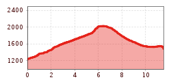
Circular hike up from the centre of Untertilliach up to the Kirchberg, continue to Kircher Alm above the tree limit, in a south-easterly direction down to Eggen and just before this, via an almost flat trail - which becomes a steep trail at the end - back to the old parish church on the Kirchberg.

Getting here

  • Arrival by public transport

    Mit dem Bus bis zur Haltestalle "Untertilliach Dorf"

More tours in the surrounding area

  • Herz-Ass Villgratental

    Difficulty: medium
    Length: 76.0 km Duration: 34:00 h Elevation uphill: 5,750 m
  • Lasörling altitude trail

    Difficulty: medium
    Length: 57.0 km Duration: 25:00 h Elevation uphill: 3,740 m
  • Venediger altitude trail

    Difficulty: difficult
    Length: 55.5 km Duration: 27:00 h Elevation uphill: 3,915 m
  • Figerhorn

    Difficulty: difficult
    Length: 6.5 km Duration: 6:00 h Elevation uphill: 807 m
  • Hike to the Venedigerhaus Innergschlöß

    Difficulty: easy
    Length: 8.5 km Duration: 2:30 h Elevation uphill: 180 m
  • Rotenkogel

    Difficulty: difficult
    Length: 3.9 km Duration: 3:00 h Elevation uphill: 383 m
  • Lasörling 3.098m

    Difficulty: difficult
    Length: 21.9 km Duration: 12:00 h Elevation uphill: 1,940 m
  • Toblacher Pfannhorn

    Difficulty: medium
    Length: 9.8 km Duration: 4:30 h Elevation uphill: 1,020 m
  • Schober trek

    Difficulty: medium
    Length: 33.0 km Duration: 30:00 h Elevation uphill: 3,200 m
  • Golzentipp 2.317 m

    Difficulty: easy
    Length: 5.6 km Duration: 2:00 h Elevation uphill: 267 m
  • Hike to Jagdhausalm 2.009m

    Difficulty: easy
    Length: 16.6 km Duration: 5:00 h Elevation uphill: 400 m
  • Große Kinigat

    Difficulty: difficult
    Length: 8.5 km Elevation uphill: 1,250 m
  • Oberseitsee - Seespitze 3.021 m

    Difficulty: difficult
    Length: 14.4 km Duration: 8:30 h Elevation uphill: 1,310 m
  • Umbal waterfalls nature force trail

    Difficulty: easy
    Length: 5.8 km Duration: 2:30 h Elevation uphill: 250 m
  • Lake Schwarzsee

    Difficulty: medium
    Length: 7.8 km Duration: 3:30 h Elevation uphill: 790 m
  • Rote Spitze 2,956 m

    Difficulty: medium
    Length: 10.2 km Duration: 5:30 h Elevation uphill: 1,260 m
  • Muhs panorama trail

    Difficulty: medium
    Length: 15.2 km Duration: 6:00 h Elevation uphill: 1,090 m
Newsletter

The mountain is calling? So does our newsletter!

In our monthly newsletter we reveal the best holiday tips for Tyrol.