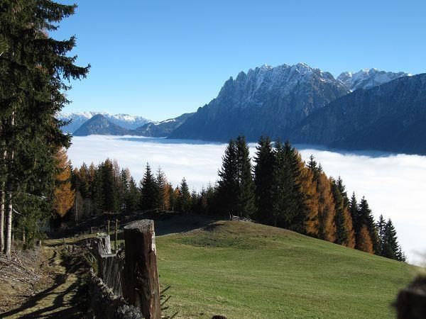
Mountain hikes Themed path "View of the Dolomites"

Gaimberg / Schober Group
Difficulty ratings: medium
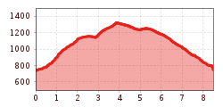
Route length: 8.5 km
Duration: 3:00 h

Themed path "View of the Dolomites"

Tour information

  • Requirement: medium
  • Length: 8.5 km
  • Duration: 3:00 h
  • Elevation uphill:700 hm
  • Elevation downhill:670 hm
Highest point1,340 m

Starting point

Zettersfeld Talstation

Finishing point

Zettersfeld Talstation
  • Fitness level 4 / 6
  • Technique 3 / 6

Features

  • Circular route

Best time of year

  • January
  • February
  • March
  • April
  • May
  • June
  • July
  • August
  • September
  • October
  • November
  • December
Source: TVB Osttirol

Description

The first section of the circular trail proceeds along the Grafenbach, which is what we talk about here. This wild stream which can be muddy, always presents a certain hazard potential for the adjacent towns during periods of intense rainfall. Protective measures such as debris barriers and forested areas are in place to prevent major damage. Unfortunately there are no longer many of the mills which were once powered by the Grafenbach to be seen, yet their significance is once again in evidence here.

Getting here

  • Arrival by public transport

    Mit dem Bus bis zur Bushaltestelle "Gaimberg Zettersfeldbahn".

  • Parking

    Parkplatz Talstation Zettersfeldbahn

Weather

Today

light rain showers
24°C/9°C
85%12.8l5 km/h

Thu

light rain showers
18°C/12°C
85%8.7l5 km/h

Fri

light rain showers
20°C/11°C
70%9.7l5 km/h

More tours in the surrounding area

  • Venediger altitude trail

    Difficulty:difficult
    Length:55.5 kmDuration:27:00 hElevation uphill:3,975 m
  • Figerhorn

    Difficulty:difficult
    Length:6.6 kmDuration:6:00 hElevation uphill:811 m
  • Theme path "Virgen crossroads"

    Difficulty:easy
    Length:3.2 kmDuration:1:00 hElevation uphill:104 m
  • Lasörling altitude trail

    Difficulty:medium
    Length:55.4 kmDuration:25:00 hElevation uphill:3,718 m
  • Muhs panorama trail

    Difficulty:medium
    Length:15.2 kmDuration:6:00 hElevation uphill:1,090 m
  • Herz-Ass Villgratental

    Difficulty:medium
    Length:75.6 kmDuration:34:00 hElevation uphill:5,703 m
  • Hike to the Venedigerhaus Innergschlöß

    Difficulty:easy
    Length:8.6 kmDuration:2:30 hElevation uphill:184 m
  • Children's mile Golzentipp

    Difficulty:easy
    Length:3.7 kmDuration:2:00 hElevation uphill:140 m
  • Iseltrail

    Difficulty:medium
    Length:75.3 kmDuration:24:30 hElevation uphill:2,347 m
  • Trail Virgentaler Sonnseitenweg

    Difficulty:medium
    Length:41.9 kmDuration:19:00 hElevation uphill:2,641 m
  • Badener Hütte

    Difficulty:difficult
    Length:23.2 kmDuration:12:00 hElevation uphill:1,754 m
  • Lucknerhaus - Stüdlhütte

    Difficulty:medium
    Length:9.3 kmDuration:4:30 hElevation uphill:862 m
  • Hiking tour to St. Pöltner Hütte and 3 lakes

    Difficulty:difficult
    Length:14.8 kmDuration:7:40 hElevation uphill:1,119 m
  • Hike to Kalser Tauernhaus

    Difficulty:medium
    Length:12.2 kmDuration:4:00 hElevation uphill:244 m
  • Hiking tour to Neue Sajathütte 2.600m

    Difficulty:medium
    Length:10.3 kmDuration:6:50 hElevation uphill:1,086 m
  • Hiking tour to Zupalsee Hütte 2.350m

    Difficulty:medium
    Length:14.9 kmDuration:8:30 hElevation uphill:1,261 m
Newsletter

The mountain is calling? So does our newsletter!

In our monthly newsletter we reveal the best holiday tips for Tyrol.