
Mountain hikes Panoramarunde über Scharwiese

Obertilliach / Gailtal Alps
Difficulty ratings: medium
Route length: 7.4 km

Suitable as an "adventure tour" for families - but the children should not be too small
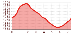
Tour information

  • Requirement: medium
  • Length: 7.4 km
  • Elevation uphill:373 hm
  • Elevation downhill:398 hm
Highest point1,648 m

Starting point

Tourismusbüro (Gemeindehaus)

Finishing point

Obertilliach (Bushaltestelle Ort)
  • Fitness level 2 / 6
  • Technique 3 / 6

Features

  • Circular route
  • Suitable for families

Best time of year

  • January
  • February
  • March
  • April
  • May
  • June
  • July
  • August
  • September
  • October
  • November
  • December

Trail condition

Asphalt- und Schotterweg, abschnittweise Steig durch Wald und über Bergwiesen

Equipment

Wanderausrüstung, festes Schuhwerk!
Source: TVB Osttirol

Description

Sometimes you have to climb over fallen trees or walk underneath them. Make sure you wear sturdy (waterproof) footwear, as you have to cross some wet spots on the mountain meadows.
From the tourist office, the path first leads to the centre of the village and then left up to the northern edge of the village. Behind the last house, we turn right and follow a somewhat steeper path through the forest up to the "Bannwaldweg". We pass the gondola lift track and follow the Bannwaldweg until, just before a large clearing, path no. 43c branches off to the left again. Firstly, briefly through a section of forest and then across open, flower-filled mountain meadows almost flat until you reach another passage through the forest. We then return via an unfortunately increasingly narrow path across relatively steeply sloping mountain meadows towards the Rals descent. Here we keep left and follow the forest path downhill towards Rals, where we can stop for refreshments at the snack station and enjoy the view.
We continue the hike in an easterly direction, initially along the tarmac municipal path, and continue straight ahead at the bend along a field path towards "Schoade" to Gärberbach and on to "Bachhäusl". After the road subway, pass Haus Waldfrieden and then keep right. Walk back along the field path past the two chapels in the direction of Obertilliach.

Nearby huts and mountain restaurants

Weather

Today

partly Cloudy
13°C/6°C
40%0.2l5 km/h

Sat

clear sky
16°C/5°C
0%0l5 km/h

Sun

mainly clear
18°C/6°C
35%0.7l5 km/h
Go to weather forecast

More tours in the surrounding area

  • Venediger altitude trail

    Difficulty:difficult
    Length:55.5 kmDuration:27:00 hElevation uphill:3,975 m
  • Figerhorn

    Difficulty:difficult
    Length:6.6 kmDuration:6:00 hElevation uphill:811 m
  • Theme path "Virgen crossroads"

    Difficulty:easy
    Length:3.2 kmDuration:1:00 hElevation uphill:104 m
  • Lasörling altitude trail

    Difficulty:medium
    Length:55.4 kmDuration:25:00 hElevation uphill:3,718 m
  • Muhs panorama trail

    Difficulty:medium
    Length:15.2 kmDuration:6:00 hElevation uphill:1,090 m
  • Herz-Ass Villgratental

    Difficulty:medium
    Length:75.6 kmDuration:34:00 hElevation uphill:5,703 m
  • Children's mile Golzentipp

    Difficulty:easy
    Length:3.7 kmDuration:2:00 hElevation uphill:140 m
  • Hike to Kalser Tauernhaus

    Difficulty:medium
    Length:12.2 kmDuration:4:00 hElevation uphill:244 m
  • Iseltrail

    Difficulty:medium
    Length:75.3 kmDuration:24:30 hElevation uphill:2,347 m
  • Trail Virgentaler Sonnseitenweg

    Difficulty:medium
    Length:41.9 kmDuration:19:00 hElevation uphill:2,641 m
  • Badener Hütte

    Difficulty:difficult
    Length:23.2 kmDuration:12:00 hElevation uphill:1,754 m
  • Lucknerhaus - Stüdlhütte

    Difficulty:medium
    Length:9.3 kmDuration:4:30 hElevation uphill:862 m
  • Hike to Neuen Reichenberger Hütte

    Difficulty:medium
    Length:18.2 kmDuration:9:00 hElevation uphill:1,252 m
  • Hiking tour to St. Pöltner Hütte and 3 lakes

    Difficulty:difficult
    Length:14.8 kmDuration:7:40 hElevation uphill:1,119 m
  • Hike to the Venedigerhaus Innergschlöß

    Difficulty:easy
    Length:8.6 kmDuration:2:30 hElevation uphill:184 m
  • Hiking tour to Neue Sajathütte 2.600m

    Difficulty:medium
    Length:10.3 kmDuration:6:50 hElevation uphill:1,086 m
Newsletter

The mountain is calling? So does our newsletter!

In our monthly newsletter we reveal the best holiday tips for Tyrol.
