Mountain hikes Themed path "Smuggler’s path"

Innervillgraten / Villgraten Mountains
Difficulty ratings: medium
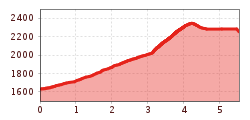
Route length: 7.0 km
Duration: 5:00 h

Themed path "Smuggler’s path"

Tour information

  • Requirement: medium
  • Length: 7.0 km
  • Duration: 5:00 h
  • Elevation uphill:800 hm
  • Elevation downhill:0 hm

Starting point

Kalksteinq

Finishing point

St. Magdalena / Gsiesertal
Source: TVB Osttirol

Description

Historical smuggling from Villgraten to Gsies. Smugglers and tollkeepers feature prominently here.
Smugglers featured for a short period of time in the history of both valleys. Borders were smuggling took place, during only in two periods of time, between 1810 and 1814 and after both World Wars. From Villgraten to Gsies it was predominantly cattle which was smuggled since better prices could be achieved there. Especially after the two world wars, food, tobacco and cigarettes were smuggled and swapped on these routes. The former smugglers’ path which is now in action again proceeds from Kalkstein via the Roßtalalm to the Kalksteiner Jöchl and continues from there through the Tscharniettal to St. Magdalena. 

More tours in the surrounding area

  • Muhs panorama trail

    Difficulty:medium
    Length:15.2 kmDuration:6:00 hElevation uphill:1,090 m
  • Herz-Ass Villgratental

    Difficulty:medium
    Length:75.6 kmDuration:34:00 hElevation uphill:5,703 m
  • Children's mile Golzentipp

    Difficulty:easy
    Length:3.7 kmDuration:2:00 hElevation uphill:140 m
  • Badener Hütte

    Difficulty:difficult
    Length:23.2 kmDuration:12:00 hElevation uphill:1,754 m
  • Lucknerhaus - Stüdlhütte

    Difficulty:medium
    Length:9.3 kmDuration:4:30 hElevation uphill:862 m
  • Hiking tour to St. Pöltner Hütte and 3 lakes

    Difficulty:difficult
    Length:14.8 kmDuration:7:40 hElevation uphill:1,119 m
  • Hike to Kalser Tauernhaus

    Difficulty:medium
    Length:12.2 kmDuration:4:00 hElevation uphill:244 m
  • Hiking tour to Neue Sajathütte 2.600m

    Difficulty:medium
    Length:10.3 kmDuration:6:50 hElevation uphill:1,086 m
  • Hiking tour to Zupalsee Hütte 2.350m

    Difficulty:medium
    Length:14.9 kmDuration:8:30 hElevation uphill:1,261 m
  • Hike to Neuen Reichenberger Hütte

    Difficulty:medium
    Length:18.2 kmDuration:9:00 hElevation uphill:1,252 m
  • Hiking tour to Lasörlinghütte 2.350m

    Difficulty:medium
    Length:14.6 kmDuration:7:50 hElevation uphill:1,135 m
  • Circular walk church St. Nikolaus

    Difficulty:easy
    Length:5.4 kmDuration:1:39 hElevation uphill:150 m
  • Lasörling 3.098m

    Difficulty:difficult
    Length:22.0 kmDuration:12:00 hElevation uphill:1,940 m
  • Lake Schwarzsee

    Difficulty:medium
    Length:7.8 kmDuration:3:30 hElevation uphill:790 m
  • Rote Spitze 2,956 m

    Difficulty:medium
    Length:10.2 kmDuration:5:30 hElevation uphill:1,260 m
Newsletter

The mountain is calling? So does our newsletter!

In our monthly newsletter we reveal the best holiday tips for Tyrol.