
Mountain hikes Anna Schutzhaus on the Ederplan

Dölsach / Kreuzeck Gruppe
Difficulty ratings: easy
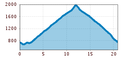
Route length: 20.5 km
Duration: 9:00 h

The Anna-Schutzhaus on the Ederplan - never heard of it? Our insider tip in the easternmost part of East Tyrol is a real feel-good place in autumn, surrounded by golden-yellow larches and with a view of the (Lienz) Dolomites.

Tour character

Easy hike on undemanding forest paths up to the Anna refuge. From the valley, with an altitude difference of almost 1,300 meters, this is an above-average distance for a hut trail, but can be shortened by starting at the intermediate saddle. From the hut, a short detour to the summit cross of the Ederplan with a beautiful panoramic view is worthwhile. The hut is a feast for the eyes, with brilliant food and the best views (open until the end of October).
Tour information

  • Requirement: easy
  • Length: 20.5 km
  • Duration: 9:00 h
  • Elevation uphill:1,338 hm
  • Elevation downhill:1,253 hm
Highest point1,985 m

Starting point

Görtschach

Finishing point

Anna Schutzhaus
  • Fitness level 2 / 6
  • Technique 2 / 6

Best time of year

  • January
  • February
  • March
  • April
  • May
  • June
  • July
  • August
  • September
  • October
  • November
  • December

Equipment

Basic equipmentformountainhikingincludessturdy hiking bootswith a goodtread, a 30-35 literbackpack, and functionalclothingbased on thelayeringprinciple, includingsufficient spare clothes. Essential itemsare rain, cold, and sunprotection, adequatefluids and food, aswellas a first-aid kit and a charged mobile phone. A mapor a GPS devicesupportsorientation. 

The informationservesas a guideline and does not claimtobe exhaustive. Equipment mustalwaysbeadaptedtothe planned route, weatherconditions, season, naturalhazards, environmental influences, and personal needs. 

Source: TVB Osttirol

Description

Starting point is Görtschach, some 1.9 km to the east of Dölsach. Leave the main road to Lienz (junction at Dölsach swimming pool) and get to the towns of Gödnach and Görtschach. Past the fire station, the road climbs to Brennerhaus, No. 14 (Schranken). The route branches out on several occasions, but signposts show the way.

From the rustic benches at the Anna Schutzhaus bothy you can take in the fantastic views from the Carnic Alps to the Lienz and Sexten Dolomites, right to the middle summits of the Schober group. All the names of the summits have been listed on the panoramic information boards, skilfully crafted in wood.

Nearby huts and mountain restaurants

Getting here

  • Arrival by public transport

    Mit dem Bus bis zur Bushaltestelle "Dölsach Kreuzwirt".

  • Parking

    Mit dem Auto Richtung Dölsach und dann bis zum "Parkplatz Schwimmbad Dölsach".
    Parkplatz Schwimmbad Dölsach

Weather

Today

clear sky
12°C/2°C
0%0l5 km/h

Sat

clear sky
11°C/1°C
45%0.2l5 km/h

Sun

light rain showers
8°C/0°C
45%1.3l5 km/h
Go to weather forecast

More tours in the surrounding area

  • Herz-Ass Villgratental

    Difficulty:medium
    Length:75.6 kmDuration:34:00 hElevation uphill:5,703 m
  • Muhs panorama trail

    Difficulty:medium
    Length:15.2 kmDuration:6:00 hElevation uphill:1,090 m
  • Figerhorn

    Difficulty:difficult
    Length:6.6 kmDuration:6:00 hElevation uphill:811 m
  • Lasörling altitude trail

    Difficulty:medium
    Length:55.4 kmDuration:25:00 hElevation uphill:3,718 m
  • Venediger altitude trail

    Difficulty:difficult
    Length:55.5 kmDuration:27:00 hElevation uphill:3,975 m
  • Theme path "Virgen crossroads"

    Difficulty:easy
    Length:3.2 kmDuration:1:00 hElevation uphill:104 m
  • Children's mile Golzentipp

    Difficulty:easy
    Length:3.7 kmDuration:2:00 hElevation uphill:140 m
  • Lucknerhaus - Stüdlhütte

    Difficulty:medium
    Length:9.3 kmDuration:4:30 hElevation uphill:862 m
  • Iseltrail

    Difficulty:medium
    Length:75.3 kmDuration:24:30 hElevation uphill:2,347 m
  • Hiking tour to St. Pöltner Hütte and 3 lakes

    Difficulty:difficult
    Length:14.8 kmDuration:7:40 hElevation uphill:1,119 m
  • Trail Virgentaler Sonnseitenweg

    Difficulty:medium
    Length:41.9 kmDuration:1 dayElevation uphill:2,641 m
  • Badener Hütte

    Difficulty:difficult
    Length:23.2 kmDuration:12:00 hElevation uphill:1,754 m
  • Hike to the Venedigerhaus Innergschlöß

    Difficulty:easy
    Length:8.6 kmDuration:2:30 hElevation uphill:184 m
  • Hike to Neuen Reichenberger Hütte

    Difficulty:medium
    Length:18.2 kmDuration:9:00 hElevation uphill:1,252 m
  • Hiking tour to Lasörlinghütte 2.350m

    Difficulty:medium
    Length:14.6 kmDuration:7:50 hElevation uphill:1,135 m
  • The Höfe Trail

    Difficulty:easy
    Length:51.2 kmDuration:10:15 hElevation uphill:1,988 m
  • Hike to Kalser Tauernhaus

    Difficulty:medium
    Length:12.2 kmDuration:4:00 hElevation uphill:244 m
Newsletter

The mountain is calling? So does our newsletter!

In our monthly newsletter we reveal the best holiday tips for Tyrol.
