Mountain hikes Circular walk church St. Nikolaus

Matrei in Osttirol / Venediger Group
Difficulty ratings: easy
Route length: 5.4 km
Duration: 1:39 h

The St. Nicholas Church circular route is suitable for both baby carriages and wheelchair users.

Tour character

  • Visit to the small church
  • moderate ascent

Tour information

  • Requirement: easy
  • Length: 5.4 km
  • Duration: 1:39 h
  • Elevation uphill:150 hm
  • Elevation downhill:150 hm
Highest point1,049 m

Starting point

Center of Matrei i. O. (Rauterplatz)

Finishing point

Center of Matrei i. O. (Rauterplatz)
  • Fitness level 2 / 6
  • Technique 2 / 6

Features

  • Circular route
  • Suitable for families
  • suitable for pushchairs

Best time of year

  • January
  • February
  • March
  • April
  • May
  • June
  • July
  • August
  • September
  • October
  • November
  • December

Trail condition

Asphalt, gravel
Source: TVB Osttirol

Description

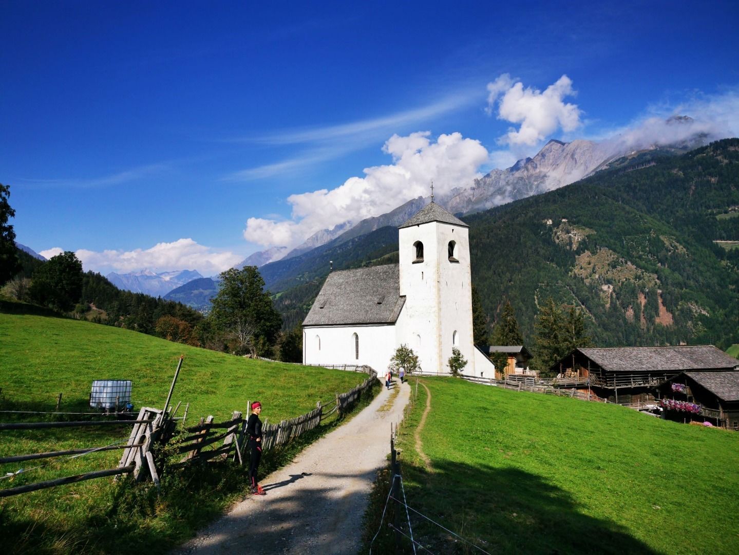
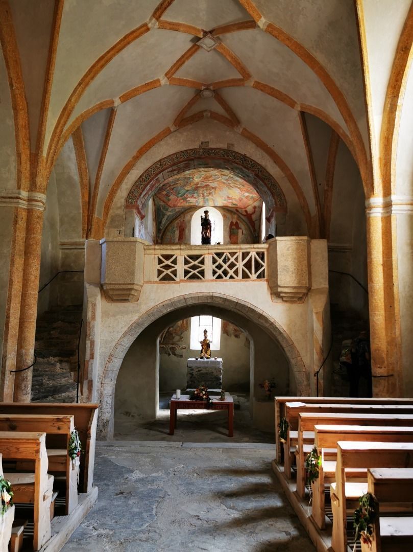
From the center of the village (Rauterplatz) you walk over the Lederer bridge (next to the butcher's shop Mühlstätter) straight ahead to the miniature golf course. Here you turn right into Bichlerstraße and walk straight over the bridge to the district Bichl. In front of the village fountain, turn right and follow the yellow signs "St. Nikolaus-Kirche". The little church is open and worth a visit. If the church is locked, you can pick up the key at the farm next door. The way back is first to the district Ganz, then over the Zeller bridge. Then turn left after the Zedlacher Bridge and follow the Tauernbach. At the estuary of the Bretterwandbach you turn right, back to the center.

Getting here

  • Arrival by public transport

    Matrei i.O. Korberplatz

  • Parking

    Parking place Korberplatz

More tours in the surrounding area

  • Figerhorn

    Difficulty:difficult
    Length:6.5 kmDuration:6:00 hElevation uphill:807 m
  • Lasörling altitude trail

    Difficulty:medium
    Length:57.0 kmDuration:25:00 hElevation uphill:3,740 m
  • Venediger altitude trail

    Difficulty:difficult
    Length:55.5 kmDuration:27:00 hElevation uphill:3,915 m
  • Theme path "Virgen crossroads"

    Difficulty:easy
    Length:3.2 kmDuration:1:00 hElevation uphill:104 m
  • Muhs panorama trail

    Difficulty:medium
    Length:15.2 kmDuration:6:00 hElevation uphill:1,090 m
  • Hiking tour to Lasörlinghütte 2.350m

    Difficulty:medium
    Length:14.6 kmDuration:7:50 hElevation uphill:1,135 m
  • Hiking tour to St. Pöltner Hütte and 3 lakes

    Difficulty:difficult
    Length:14.8 kmDuration:7:40 hElevation uphill:1,119 m
  • Hike to Neuen Reichenberger Hütte

    Difficulty:medium
    Length:18.2 kmDuration:9:00 hElevation uphill:1,252 m
  • Hike to Kalser Tauernhaus

    Difficulty:medium
    Length:12.2 kmDuration:4:00 hElevation uphill:244 m
  • Hiking tour to Neue Sajathütte 2.600m

    Difficulty:medium
    Length:10.3 kmDuration:6:50 hElevation uphill:1,086 m
  • Badener Hütte

    Difficulty:difficult
    Length:23.2 kmDuration:12:00 hElevation uphill:1,754 m
  • Hiking tour to Zupalsee Hütte 2.350m

    Difficulty:medium
    Length:14.9 kmDuration:8:30 hElevation uphill:1,261 m
  • Lucknerhaus - Stüdlhütte

    Difficulty:medium
    Length:9.3 kmDuration:4:30 hElevation uphill:862 m
  • Böses Weibl

    Difficulty:difficult
    Length:14.1 kmDuration:8:00 hElevation uphill:1,193 m
  • Lasörling 3.098m

    Difficulty:difficult
    Length:22.0 kmDuration:12:00 hElevation uphill:1,940 m
  • Hike to the Venedigerhaus Innergschlöß

    Difficulty:easy
    Length:8.6 kmDuration:2:30 hElevation uphill:184 m
  • Rotenkogel

    Difficulty:difficult
    Length:3.9 kmDuration:3:00 hElevation uphill:383 m
  • Umbal waterfalls nature force trail

    Difficulty:easy
    Length:6.0 kmDuration:2:30 hElevation uphill:257 m
  • Glacier trail Innergschlöss/Schlatenkees

    Difficulty:medium
    Length:9.4 kmDuration:4:50 hElevation uphill:680 m
Newsletter

The mountain is calling? So does our newsletter!

In our monthly newsletter we reveal the best holiday tips for Tyrol.