Mountain hikes Walking trail Dorfrundweg

Außervillgraten / Villgraten Mountains
Difficulty ratings: easy
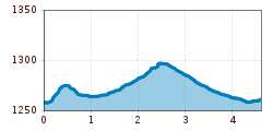
Route length: 4.6 km
Duration: 2:00 h

Unterweg der Herz-Ass Villgratental
Tour information

  • Requirement: easy
  • Length: 4.6 km
  • Duration: 2:00 h
  • Elevation uphill:60 hm
  • Elevation downhill:55 hm
Highest point1,301 m

Starting point

Dorfzentrum Außervillgraten

Finishing point

Glinze
  • Fitness level 1 / 6
  • Technique 1 / 6

Features

  • Suitable for families

Best time of year

  • January
  • February
  • March
  • April
  • May
  • June
  • July
  • August
  • September
  • October
  • November
  • December

Equipment

Basic equipmentformountainhikingincludessturdy hiking bootswith a goodtread, a 30-35 literbackpack, and functionalclothingbased on thelayeringprinciple, includingsufficient spare clothes. Essential itemsare rain, cold, and sunprotection, adequatefluids and food, aswellas a first-aid kit and a charged mobile phone. A mapor a GPS devicesupportsorientation. 

The informationservesas a guideline and does not claimtobe exhaustive. Equipment mustalwaysbeadaptedtothe planned route, weatherconditions, season, naturalhazards, environmental influences, and personal needs. 

Source: TVB Osttirol

Weather

Today

partly Cloudy
17°C/2°C
0%0l0 km/h

Fri

mainly clear
18°C/2°C
0%0l0 km/h

Sat

cloudy
15°C/3°C
10%0l0 km/h
Go to weather forecast

More tours in the surrounding area

Newsletter

The mountain is calling? So does our newsletter!

In our monthly newsletter we reveal the best holiday tips for Tyrol.