Mountain hikes Waldpfad Lavant

Lavant / Gailtal Alps
Difficulty ratings: easy
Route length: 3.5 km
Duration: 1:00 h

Waldpfad Lavant

Tour information

  • Requirement: easy
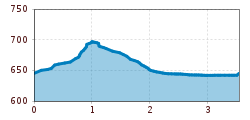
  • Length: 3.5 km
  • Duration: 1:00 h
  • Elevation uphill:65 hm
  • Elevation downhill:65 hm
Highest point707 m

Starting point

Lavant Wacht

Finishing point

Lavant Wacht
  • Fitness level 1 / 6
  • Technique 2 / 6

Features

  • Circular route
  • Suitable for families

Best time of year

  • January
  • February
  • March
  • April
  • May
  • June
  • July
  • August
  • September
  • October
  • November
  • December

Trail condition

Großteils Schotterweg, zum Frauenbach Wasserfall ein schmaler Steil.
Source: TVB Osttirol

Description

The Lavant forest trail starts in the Wacht district of the Lavant municipality and first leads along a wide gravel path then on along a somewhat narrower but easy uphill path to the Frauenbach waterfall. There, at the Hochstadel north face, there is a viewing platform from which you can enjoy a magnificent view of the Frauenbach waterfall. Over the years, the water has formed smooth walls and hollowed-out basins.
Back on the gravel path, the route continues along the Frauenbach to the northeastern part of the forest back to the starting point. The circuit is especially suitable for families, because the many wooden figures such as squirrels, woodpecker, owl & co. convey valuable knowledge and are particularly interesting for children.
Access is only possible at certain times due to military exercises! Please obtain information beforehand at the East Tyrol tourist information office.

Weather

Today

partly Cloudy
23°C/11°C
40%0.3l5 km/h

Sun

cloudy
24°C/13°C
50%0.3l5 km/h

Mon

light rain showers
25°C/14°C
50%4.3l5 km/h
Go to weather forecast

More tours in the surrounding area

  • Rollitour with Swiss Trac

    Difficulty:easy
    Length:3.2 kmDuration:1:30 hElevation uphill:135 m
  • Muhs panorama trail

    Difficulty:medium
    Length:15.2 kmDuration:6:00 hElevation uphill:1,090 m
  • Herz-Ass Villgratental

    Difficulty:medium
    Length:75.6 kmDuration:34:00 hElevation uphill:5,703 m
  • Venediger altitude trail

    Difficulty:difficult
    Length:55.5 kmDuration:27:00 hElevation uphill:3,975 m
  • Figerhorn

    Difficulty:difficult
    Length:6.6 kmDuration:6:00 hElevation uphill:811 m
  • Theme path "Virgen crossroads"

    Difficulty:easy
    Length:3.2 kmDuration:1:00 hElevation uphill:104 m
  • Lasörling altitude trail

    Difficulty:medium
    Length:55.4 kmDuration:25:00 hElevation uphill:3,718 m
  • Hike to Kalser Tauernhaus

    Difficulty:medium
    Length:12.2 kmDuration:4:00 hElevation uphill:244 m
  • Iseltrail

    Difficulty:medium
    Length:75.3 kmDuration:24:30 hElevation uphill:2,347 m
  • Hiking tour to Neue Sajathütte 2.600m

    Difficulty:medium
    Length:10.3 kmDuration:6:50 hElevation uphill:1,086 m
  • Hiking tour to Zupalsee Hütte 2.350m

    Difficulty:medium
    Length:14.9 kmDuration:8:30 hElevation uphill:1,261 m
  • Trail Virgentaler Sonnseitenweg

    Difficulty:medium
    Length:41.9 kmDuration:19:00 hElevation uphill:2,641 m
  • Badener Hütte

    Difficulty:difficult
    Length:23.2 kmDuration:12:00 hElevation uphill:1,754 m
  • Lucknerhaus - Stüdlhütte

    Difficulty:medium
    Length:9.3 kmDuration:4:30 hElevation uphill:862 m
  • Hike to Neuen Reichenberger Hütte

    Difficulty:medium
    Length:18.2 kmDuration:9:00 hElevation uphill:1,252 m
  • Hiking tour to Lasörlinghütte 2.350m

    Difficulty:medium
    Length:14.6 kmDuration:7:50 hElevation uphill:1,135 m
  • Hiking tour to St. Pöltner Hütte and 3 lakes

    Difficulty:difficult
    Length:14.8 kmDuration:7:40 hElevation uphill:1,119 m
Newsletter

The mountain is calling? So does our newsletter!

In our monthly newsletter we reveal the best holiday tips for Tyrol.