
Mountain hikes Circular hike Anras village tour

Anras / Villgraten Mountains
Difficulty ratings: easy
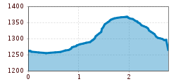
Route length: 2.8 km
Duration: 1:30 h

easy hike in Anras

Tour information

  • Requirement: easy
  • Length: 2.8 km
  • Duration: 1:30 h
  • Elevation uphill:130 hm
  • Elevation downhill:130 hm
  • Fitness level 2 / 6
  • Technique 2 / 6

Features

  • Circular route

Best time of year

  • January
  • February
  • March
  • April
  • May
  • June
  • July
  • August
  • September
  • October
  • November
  • December

Equipment

Basic equipmentformountainhikingincludessturdy hiking bootswith a goodtread, a 30-35 literbackpack, and functionalclothingbased on thelayeringprinciple, includingsufficient spare clothes. Essential itemsare rain, cold, and sunprotection, adequatefluids and food, aswellas a first-aid kit and a charged mobile phone. A mapor a GPS devicesupportsorientation. 

The informationservesas a guideline and does not claimtobe exhaustive. Equipment mustalwaysbeadaptedtothe planned route, weatherconditions, season, naturalhazards, environmental influences, and personal needs. 


Source: TVB Osttirol

Description

The Anras village tour starts at the so-called "Pfleghaus". We start in a southerly direction through the small village of Anras towards the "Ried" district. After approx. 1.5 km, we turn left to the "Hohes Kreuz", where the first power place is located. Continue along a dirt track in the direction of the sports field. After approx. 500 m, we turn right and after approx. 70 m along a tarmac road, we continue along a field path for approx. 100 m. Then we turn left again onto a forest path, where you will find theme board no. 5. After approx. 150 m in the shady forest, we come to a tarmac road again. On this road we return to the starting point and pass theme board no. 6.
The Anraser Dorfrunden can also be walked in the opposite direction. There are seating facilities and a toilet at the sports field along the way.

Nearby huts and mountain restaurants

Weather

Today

clear sky
6°C/-1°C
5%0l10 km/h

Tue

partly Cloudy
6°C/-1°C
15%0l5 km/h

Wed

cloudy
5°C/0°C
5%0l5 km/h
Go to weather forecast

More tours in the surrounding area

  • Figerhorn

    Difficulty:difficult
    Length:6.6 kmDuration:6:00 hElevation uphill:811 m
  • Theme path "Virgen crossroads"

    Difficulty:easy
    Length:3.2 kmDuration:1:00 hElevation uphill:104 m
  • Lasörling altitude trail

    Difficulty:medium
    Length:55.4 kmDuration:25:00 hElevation uphill:3,718 m
  • Venediger altitude trail

    Difficulty:difficult
    Length:55.5 kmDuration:27:00 hElevation uphill:3,975 m
  • Children's mile Golzentipp

    Difficulty:easy
    Length:3.7 kmDuration:2:00 hElevation uphill:140 m
  • Böses Weibele

    Difficulty:medium
    Length:13.6 kmDuration:6:30 hElevation uphill:965 m
  • Badener Hütte

    Difficulty:difficult
    Length:23.2 kmDuration:12:00 hElevation uphill:1,754 m
  • Hiking tour to St. Pöltner Hütte and 3 lakes

    Difficulty:difficult
    Length:14.8 kmDuration:7:40 hElevation uphill:1,119 m
  • Lucknerhaus - Stüdlhütte

    Difficulty:medium
    Length:9.3 kmDuration:4:30 hElevation uphill:862 m
  • Trail Virgentaler Sonnseitenweg

    Difficulty:medium
    Length:41.9 kmDuration:1 dayElevation uphill:2,641 m
  • Iseltrail

    Difficulty:medium
    Length:75.3 kmDuration:24:30 hElevation uphill:2,347 m
  • Lake Schwarzsee

    Difficulty:medium
    Length:7.8 kmDuration:3:30 hElevation uphill:790 m
  • Rotenkogel

    Difficulty:difficult
    Length:3.9 kmDuration:3:00 hElevation uphill:383 m
  • Rote Spitze 2,956 m

    Difficulty:medium
    Length:10.2 kmDuration:5:30 hElevation uphill:1,260 m
  • Böses Weibl

    Difficulty:difficult
    Length:14.1 kmDuration:8:00 hElevation uphill:1,193 m
  • Dorfberg

    Difficulty:medium
    Length:17.6 kmDuration:5:30 hElevation uphill:770 m
Newsletter

The mountain is calling? So does our newsletter!

In our monthly newsletter we reveal the best holiday tips for Tyrol.
